|
search place name
|
||
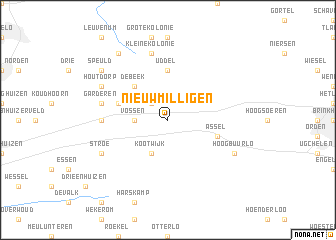
Nieuw-Milligen (Gelderland, Netherlands)Nieuw-Milligen is a town in the Gelderland region of Netherlands. An overview map of the region around Nieuw-Milligen is displayed below.
regional and 3d topo map of Nieuw-Milligen, Netherlands ::
Nieuw-Milligen airports ::
The nearest airport is UTC - Soesterberg, located 36.1 km west of Nieuw-Milligen.
Other airports nearby include AMS - Amsterdam Schiphol (70.4 km west), ENS - Enschede Twenthe (74.7 km east), EIN - Eindhoven (89.8 km south), LID - Valkenburg (93.5 km west), Nearby towns ::
Meerveld (2.2km north west) //
Vossen (2.3km west) //
Kootwijk (3.9km south) //
De Beek (4.3km north west) //
Uddel (5.6km north) //
Ouwendorp (3.9km north west) //
Assel (3.9km south east) //
Oud-Milligen (4.5km west) //
Garderen (4.9km west) //
Kleine Kolonie (7.5km north) //
Houtdorp (5.9km north west) //
Stroe (5.9km south west) //
Hoog-Buurlo (5.9km south east) //
Speuld (7.2km north west) //
Staverden (8.2km north west) //
[all distances 'as the bird flies' and approximate] 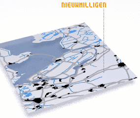 Places with similar names to Nieuw-Milligen, Netherlands ::
// Namolojan (GH)
Disclaimer :: Information on this page comes without warranty of any kind |
||
|
Where is Nieuw-Milligen? Elevation and coordinates ::
Latitude (lat): 52°13'0"N Longitude (lon): 5°47'0"E
Elevation (approx.): 42m (map arrows pan, magnifying glasses zoom) |
||
|
Visiting Nieuw-Milligen? Hotel/Accommodation ::
Book a hotel in Nieuw-Milligen Travel Guide ::
Buy a travel guide for Netherlands rental cars ::
car rental offers GPS waypoint ::
download a GPX waypoint (PoI) of Nieuw-Milligen for your GPS receiver
|
||