|
search place name
|
||
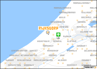
Rijksdorp (Zuid-Holland, Netherlands)Rijksdorp is a town in the Zuid-Holland region of Netherlands. An overview map of the region around Rijksdorp is displayed below.
regional and 3d topo map of Rijksdorp, Netherlands ::
Rijksdorp airports ::
The nearest airport is LID - Valkenburg, located 2.4 km east of Rijksdorp.
Other airports nearby include RTM - Rotterdam (23.6 km south), AMS - Amsterdam Schiphol (30.4 km north east), UTC - Soesterberg (61.3 km east), WOE - Woensdrecht (79.9 km south), Nearby towns ::
De Pan (1.1km east) //
Wassenaar (2.2km south east) //
Oostdorp (2.2km south east) //
Kievietsduin (3.9km south) //
Deijleroord (2.9km south east) //
Maaldrift (2.9km south east) //
Katwijk aan Zee (4.3km north east) //
Katwijk aan de Rijn (4.3km north east) //
Den Deijl (4.3km south east) //
Kerkehout (5.6km south) //
De Kieviet (5.7km south) //
Valkenburg (3.9km north east) //
Mariahoeve (7.5km south) //
Rijnsburg (4.9km east) //
Prinsenhof (7.5km south) //
Rijndijk (4.9km east) //
De Klei (6.5km north east) //
Adegeest (5.9km south east) //
Voorschoten (5.9km south east) //
Duinzigt (8.2km south west) //
Noordwijk-Binnen (8.7km north east) //
Dutten Del (8.7km south west) //
[all distances 'as the bird flies' and approximate] 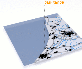 Places with similar names to Rijksdorp, Netherlands :: Disclaimer :: Information on this page comes without warranty of any kind |
||
|
Where is Rijksdorp? Elevation and coordinates ::
Latitude (lat): 52°10'0"N Longitude (lon): 4°23'0"E
Elevation (approx.): 16m (map arrows pan, magnifying glasses zoom) |
||
|
Visiting Rijksdorp? Hotel/Accommodation ::
Book a hotel in Rijksdorp Travel Guide ::
Buy a travel guide for Netherlands rental cars ::
car rental offers GPS waypoint ::
download a GPX waypoint (PoI) of Rijksdorp for your GPS receiver
|
||