|
search place name
|
||
Sliedrecht (Zuid-Holland, Netherlands)Sliedrecht is a town in the Zuid-Holland region of Netherlands. An overview map of the region around Sliedrecht is displayed below.
regional and 3d topo map of Sliedrecht, Netherlands ::

Sliedrecht airports ::
The nearest airport is RTM - Rotterdam, located 27.5 km north west of Sliedrecht.
Other airports nearby include LID - Valkenburg (45.7 km north west), UTC - Soesterberg (49.2 km north east), WOE - Woensdrecht (50.4 km south west), AMS - Amsterdam Schiphol (54.7 km north), Nearby towns ::
Baanhoek (2.2km north west) //
Wijngaarden (3.7km north) //
Matena (2.9km north west) //
Kop van ʼt Land (3.9km south) //
Oudendijk (4.4km south west) //
Dubbeldam (4.4km south west) //
De Peulen (3.4km east) //
Oosteind (3.9km north west) //
Bleskensgraaf (5.7km north) //
Hofwegen (5.7km north) //
Blaasbalg (3.9km south east) //
Giessendam (4.9km east) //
Neder-Hardinxveld (4.9km east) //
Oud-Alblas (5.9km north west) //
Brandwijk (8.2km north east) //
Gijbeland (8.2km north east) //
Kooiwijk (7.2km north west) //
Molenaarsgraaf (8.7km north east) //
[all distances 'as the bird flies' and approximate] 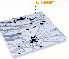 Places with similar names to Sliedrecht, Netherlands ::
// Cill Droichid (IE)
Disclaimer :: Information on this page comes without warranty of any kind |
||
|
Where is Sliedrecht? Elevation and coordinates ::
Latitude (lat): 51°49'0"N Longitude (lon): 4°46'0"E
Elevation (approx.): 3m (map arrows pan, magnifying glasses zoom) |
||
|
Visiting Sliedrecht? Hotel/Accommodation ::
Book a hotel in Sliedrecht Travel Guide ::
Buy a travel guide for Netherlands rental cars ::
car rental offers GPS waypoint ::
download a GPX waypoint (PoI) of Sliedrecht for your GPS receiver
|
||