|
search place name
|
||
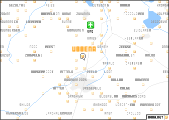
Ubbena (Drenthe, Netherlands)Ubbena is a town in the Drenthe region of Netherlands. An overview map of the region around Ubbena is displayed below.
regional and 3d topo map of Ubbena, Netherlands ::
Ubbena airports ::
The nearest airport is GRQ - Groningen Eelde, located 7.8 km north of Ubbena.
Other airports nearby include LWR - Leeuwarden (57.5 km west), EME - Emden (58.2 km north east), BMK - Borkum (61.4 km north), NRD - Norderney (85.4 km north east), Nearby towns ::
Rhee (1.9km south) //
Zeijen (1.1km west) //
Ter Aard (2.2km south west) //
Peelo (3.9km south) //
Vries (3.9km north) //
Heideheim (2.9km north east) //
Tynaarlo (4.3km north east) //
Pittelo (4.3km south west) //
Assen (5.7km south) //
Noorderpark (5.7km south) //
Taarlo (3.8km south east) //
Donderen (5.7km north) //
Loon (5.0km south east) //
Halfweg (6.0km north) //
Vredeveld (7.5km south) //
Anreep (7.5km south) //
De Punt (7.5km north) //
Yde (7.5km north) //
Baggel Huizen (7.5km south) //
Peest (4.8km north west) //
Kloosterveen (6.5km south west) //
Deurze (7.7km south) //
Schieven (7.7km south) //
Kort Bossen (7.7km south) //
Bunne (7.7km north) //
Balloo (7.1km south east) //
Witten (8.1km south west) //
[all distances 'as the bird flies' and approximate]  Places with similar names to Ubbena, Netherlands ::
Disclaimer :: Information on this page comes without warranty of any kind |
||
|
Where is Ubbena? Elevation and coordinates ::
Latitude (lat): 53°3'0"N Longitude (lon): 6°34'0"E
Elevation (approx.): 8m (map arrows pan, magnifying glasses zoom) |
||
|
Visiting Ubbena? Hotel/Accommodation ::
Book a hotel in Ubbena Travel Guide ::
Buy a travel guide for Netherlands rental cars ::
car rental offers GPS waypoint ::
download a GPX waypoint (PoI) of Ubbena for your GPS receiver
|
||