|
search place name
|
||
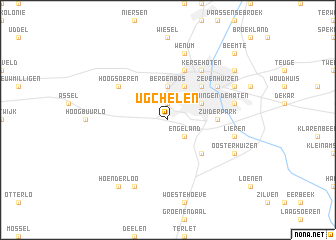
Ugchelen (Gelderland, Netherlands)Ugchelen is a town in the Gelderland region of Netherlands. An overview map of the region around Ugchelen is displayed below.
regional and 3d topo map of Ugchelen, Netherlands ::
Ugchelen airports ::
The nearest airport is UTC - Soesterberg, located 45.4 km west of Ugchelen.
Other airports nearby include ENS - Enschede Twenthe (65.0 km east), AMS - Amsterdam Schiphol (81.1 km west), EIN - Eindhoven (90.2 km south west), LID - Valkenburg (103.7 km west), Nearby towns ::
Orden (1.9km north) //
Driehuizen (1.9km north) //
Engeland (2.2km south east) //
Berg en Bos (3.7km north) //
Brinkhorst (3.9km north) //
Wormingen (2.9km north east) //
Beekbergen (4.3km south east) //
Apeldoorn (4.3km north east) //
Zuiderpark (3.4km east) //
Het Loo (5.7km north) //
Kersehoten (6.0km north) //
De Vlijt (6.0km north) //
Hoog-Soeren (5.0km north west) //
Zevenhuizen (5.0km north east) //
Lieren (4.9km east) //
Wenum (7.5km north) //
De Maten (4.9km east) //
De Krim (7.8km south) //
Oosterhuizen (5.9km south east) //
De Mheen (5.9km north east) //
Hoenderloo (8.2km south west) //
Hoog-Baarlo (8.2km south west) //
Anklaar (7.2km north east) //
Beemte (8.7km north east) //
[all distances 'as the bird flies' and approximate]  Places with similar names to Ugchelen, Netherlands :: Disclaimer :: Information on this page comes without warranty of any kind |
||
|
Where is Ugchelen? Elevation and coordinates ::
Latitude (lat): 52°11'0"N Longitude (lon): 5°56'0"E
Elevation (approx.): 31m (map arrows pan, magnifying glasses zoom) |
||
|
Visiting Ugchelen? Hotel/Accommodation ::
Book a hotel in Ugchelen Travel Guide ::
Buy a travel guide for Netherlands rental cars ::
car rental offers GPS waypoint ::
download a GPX waypoint (PoI) of Ugchelen for your GPS receiver
|
||