|
search place name
|
||
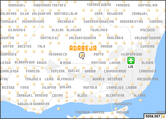
A da Beja (Lisboa, Portugal)A da Beja is a town in the Lisboa region of Portugal. An overview map of the region around A da Beja is displayed below.
regional and 3d topo map of A da Beja, Portugal ::
nearby GPS traces from timatio ::
A da Beja airports ::
The nearest airport is LIS - Lisbon Lisboa, located 8.5 km east of A da Beja.
Other airports nearby include FAO - Faro (225.8 km south east), Nearby towns ::
Falagueira (1.9km south) //
Caneças (1.9km north) //
Alfornelos (2.3km south east) //
Olival (2.3km south west) //
Pendão (2.3km south west) //
Paiã (2.9km east) //
Famões (2.9km east) //
Porto (2.9km east) //
Amadora (3.7km south) //
Camarões (3.7km north) //
Vale de Nogueira (3.7km north) //
Machados (2.9km west) //
Pontinha (3.4km south east) //
Damaia (4.0km south) //
Amoreira (3.4km north east) //
Queluz (4.0km south) //
Campos (4.0km north) //
Além (4.0km north) //
Idanha (3.4km south west) //
Belas (3.4km south west) //
Dona Maria (4.0km north) //
Bemfica (4.7km south east) //
Montemor (4.7km north east) //
Venda Seca (4.3km west) //
Pombais (4.3km east) //
Odivelas (4.3km east) //
A dos Calvos (5.7km north) //
Paço do Lumiar (4.7km south east) //
Carnide (4.7km south east) //
[all distances 'as the bird flies' and approximate]  Places with similar names to A da Beja, Portugal ::
Disclaimer :: Information on this page comes without warranty of any kind |
||
|
Where is A da Beja? Elevation and coordinates ::
Latitude (lat): 38°47'0"N Longitude (lon): 9°14'0"W
Elevation (approx.): 262m (map arrows pan, magnifying glasses zoom) |
||
|
Visiting A da Beja? Hotel/Accommodation ::
Book a hotel in A da Beja Travel Guide ::
Buy a travel guide for Portugal rental cars ::
car rental offers GPS waypoint ::
download a GPX waypoint (PoI) of A da Beja for your GPS receiver
|
||