|
search place name
|
||
Adrão (Viana do Castelo, Portugal)Adrão is a town in the Viana do Castelo region of Portugal. An overview map of the region around Adrão is displayed below.
regional and 3d topo map of Adrão, Portugal ::

Adrão airports ::
The nearest airport is VGO - Vigo, located 46.9 km north west of Adrão.
Other airports nearby include OPO - Porto (82.5 km south west), VRL - Vila Real (83.9 km south east), SCQ - Santiago (109.7 km north), BGC - Braganca (128.2 km east), Nearby towns ::
Assureira (1.9km south) //
Tibo (2.3km north east) //
Gavieira (3.7km north) //
Rouças (3.7km north) //
Várzea (3.3km south east) //
Teso (4.0km south) //
Campo Grande (4.0km south) //
Paradela (4.6km south east) //
Alto da Barreira (5.6km south) //
Cunhas (5.6km south) //
Pedras de Moledo (5.7km south) //
Souto (5.7km south) //
Soajo (5.7km south) //
Vilarinho das Quartas (6.2km south west) //
Senhora da Peneda (6.2km north east) //
Cidadelhe (7.4km south) //
Paradamonte (7.5km south) //
Mosteirô (7.5km south) //
Vilar de Soente (6.9km south west) //
Lindoso (6.9km south east) //
Branda da Aveleira (7.9km north) //
Parada (7.9km south) //
Ermelo (7.9km south) //
Ribeiro de Baixo (6.6km north east) //
Ribeiro de Cima (7.8km north east) //
[all distances 'as the bird flies' and approximate] 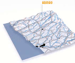 Places with similar names to Adrão, Portugal ::
Disclaimer :: Information on this page comes without warranty of any kind |
||
|
Where is Adrão? Elevation and coordinates ::
Latitude (lat): 41°55'0"N Longitude (lon): 8°15'0"W
Elevation (approx.): 632m (map arrows pan, magnifying glasses zoom) |
||
|
Visiting Adrão? Hotel/Accommodation ::
Book a hotel in Adrão Travel Guide ::
Buy a travel guide for Portugal rental cars ::
car rental offers GPS waypoint ::
download a GPX waypoint (PoI) of Adrão for your GPS receiver
|
||