|
search place name
|
||
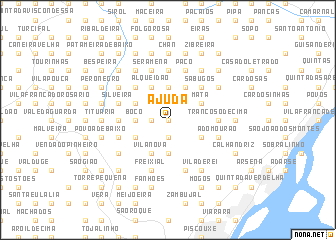
Ajuda (Lisboa, Portugal)Ajuda is a town in the Lisboa region of Portugal. An overview map of the region around Ajuda is displayed below.
regional and 3d topo map of Ajuda, Portugal ::
Ajuda airports ::
The nearest airport is LIS - Lisbon Lisboa, located 18.7 km south of Ajuda.
Other airports nearby include FAO - Faro (238.1 km south east), Nearby towns ::
Arranhó (0.0km north) //
A dos Arcos (1.9km north) //
Alcubela de Baixo (1.4km west) //
Carvalhal (1.4km west) //
Alrota (1.9km south) //
Além (2.3km north east) //
Alcareia (2.3km north west) //
Batalha (3.7km north) //
Pedralgo (3.7km north) //
Bemposta (3.7km south) //
Cachoeira (2.9km west) //
Boco (2.9km west) //
Louriceira de Baixo (4.0km north) //
Alqueidão (4.0km north) //
Mata (3.4km north east) //
São Tiago dos Velhos (3.4km south east) //
Vila Nova (4.0km south) //
A do Baço (3.4km north west) //
Cartaxaria (3.4km south west) //
Tesoureira (3.4km south west) //
Carvalha (4.7km north east) //
Sabugos (4.7km north east) //
Casais (4.7km north west) //
Adega (5.6km north) //
Monfalim (5.6km north) //
Vila de Canas (4.3km west) //
Trancoso de Cima (4.3km east) //
Paço (5.7km north) //
Martim Afonso (5.7km north) //
[all distances 'as the bird flies' and approximate]  Places with similar names to Ajuda, Portugal ::
Disclaimer :: Information on this page comes without warranty of any kind |
||
|
Where is Ajuda? Elevation and coordinates ::
Latitude (lat): 38°57'0"N Longitude (lon): 9°8'0"W
Elevation (approx.): 226m (map arrows pan, magnifying glasses zoom) |
||
|
Visiting Ajuda? Hotel/Accommodation ::
Book a hotel in Ajuda Travel Guide ::
Buy a travel guide for Portugal rental cars ::
car rental offers GPS waypoint ::
download a GPX waypoint (PoI) of Ajuda for your GPS receiver
|
||