|
search place name
|
||
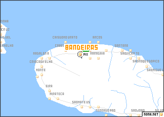
Bandeiras (Açores, Portugal)Bandeiras is a town in the Açores region of Portugal. An overview map of the region around Bandeiras is displayed below.
regional and 3d topo map of Bandeiras, Portugal ::
Bandeiras airports ::
The nearest airport is PIX - Pico, located 2.5 km north of Bandeiras.
Other airports nearby include HOR - Horta (23.2 km west), SJZ - Sao Jorge Island Sao Jorge (28.0 km north east), GRW - Graciosa Island Graciosa (72.0 km north east), TER - Lajes (terceira Island) Lajes (121.0 km east), Nearby towns ::
Laje (1.9km north) //
Porto Cachorro (1.9km north) //
Farrobo (1.4km east) //
Lajido do Meio (2.4km north east) //
Maragaia (2.9km east) //
Cabeço Chão (3.4km north west) //
Lajido (4.0km north) //
Arcos (4.7km north east) //
Cais do Mourato (4.7km north west) //
Santa Luzia (4.7km north east) //
Cabo Branco (5.8km west) //
Sete Cidades (5.8km west) //
Eira (9.4km south west) //
[all distances 'as the bird flies' and approximate] 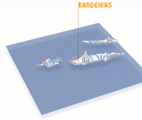 Places with similar names to Bandeiras, Portugal ::
// Ben Driss (MA)
// Bainders (DE)
// Bondyrz (PL)
// Banī Idrīs (EG)
// Bondārūz (IR)
// Boon Terrace (US)
// Banderas (EC)
// Banderas (EC)
// Bontrasi (GH)
// Banderas (MX)
Disclaimer :: Information on this page comes without warranty of any kind |
||
|
Where is Bandeiras? Elevation and coordinates ::
Latitude (lat): 38°32'0"N Longitude (lon): 28°27'0"W
Elevation (approx.): 184m (map arrows pan, magnifying glasses zoom) |
||
|
Visiting Bandeiras? Hotel/Accommodation ::
Book a hotel in Bandeiras Travel Guide ::
Buy a travel guide for Portugal rental cars ::
car rental offers GPS waypoint ::
download a GPX waypoint (PoI) of Bandeiras for your GPS receiver
|
||