|
search place name
|
||
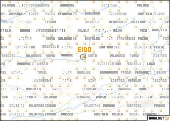
Eido (Braga, Portugal)Eido is a town in the Braga region of Portugal. An overview map of the region around Eido is displayed below.
regional and 3d topo map of Eido, Portugal ::
Eido airports ::
The nearest airport is OPO - Porto, located 44.2 km south of Eido.
Other airports nearby include VGO - Vigo (66.8 km north), VRL - Vila Real (80.0 km south east), SCQ - Santiago (140.7 km north), BGC - Braganca (155.3 km east), Nearby towns ::
Vilar das Almas (0.0km north) //
Igreja Nova (1.9km south) //
Paredes (1.9km south) //
Bocaça Maia (1.9km south) //
Rua Direita (1.4km west) //
Escariz (1.4km east) //
Xisto (1.4km east) //
Langra (1.4km west) //
Vales (1.4km east) //
Talho (1.9km north) //
Santo António (1.9km north) //
Ponte de Anhel (2.3km south west) //
Parada de Gatim (2.3km south east) //
Alheira (2.3km south west) //
Sandiãis (2.3km north west) //
Quinteiros (2.3km north west) //
Escariz (2.3km north east) //
Gaifar (2.3km north west) //
Baralde (2.3km north west) //
Entre Devesas (2.3km north east) //
Sugilde (3.7km south) //
Panque (2.8km west) //
Lugar do Monte (2.8km east) //
Cachopo (2.8km east) //
Calvelo (3.7km north) //
Cervães (4.0km south) //
Real (4.0km south) //
Bom Despacho (4.0km south) //
Louredo (4.0km south) //
[all distances 'as the bird flies' and approximate]  Places with similar names to Eido, Portugal ::
Disclaimer :: Information on this page comes without warranty of any kind |
||
|
Where is Eido? Elevation and coordinates ::
Latitude (lat): 41°38'0"N Longitude (lon): 8°33'0"W
Elevation (approx.): 189m (map arrows pan, magnifying glasses zoom) |
||
|
Visiting Eido? Hotel/Accommodation ::
Book a hotel in Eido Travel Guide ::
Buy a travel guide for Portugal rental cars ::
car rental offers GPS waypoint ::
download a GPX waypoint (PoI) of Eido for your GPS receiver
|
||