|
search place name
|
||
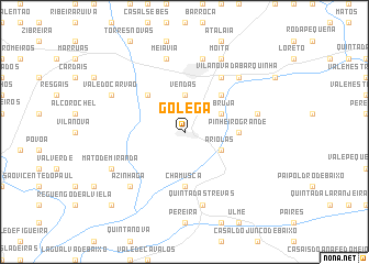
Golegã (Santarém, Portugal)Golegã is a town in the Santarém region of Portugal. An overview map of the region around Golegã is displayed below.
regional and 3d topo map of Golegã, Portugal ::
Golegã airports ::
The nearest airport is LIS - Lisbon Lisboa, located 88.9 km south west of Golegã.
Other airports nearby include BJZ - Badajoz Talavera La Real (154.4 km east), OPO - Porto (205.9 km north), VRL - Vila Real (218.0 km north), Nearby towns ::
Vendas (3.7km north) //
Labruja (3.4km north east) //
Quinta da Arresima (3.4km south east) //
Ariolas (3.4km south east) //
Quinta dos Arneiros (3.4km south east) //
São Caetano (4.7km north east) //
Riachos (4.7km north west) //
Chamusca (5.6km south) //
Pinheiro Grande (4.3km east) //
Cabeças do Pinheiro (4.3km east) //
Cabeças (4.3km east) //
Quinta da Cardiga (6.3km north east) //
Carregueira (6.0km east) //
Entroncamento (7.6km north) //
Quinta das Trevas (7.6km south) //
Carregal (7.6km south) //
Meia Via (7.6km north) //
Azinhaga (7.0km south west) //
Vila Nova da Barquinha (7.0km north east) //
Mato de Miranda (6.8km south west) //
Moita (7.9km north) //
Boquilobo (6.8km north west) //
Vale do Carvão (6.8km north west) //
Pombalinho (9.4km south west) //
[all distances 'as the bird flies' and approximate]  Places with similar names to Golegã, Portugal ::
Disclaimer :: Information on this page comes without warranty of any kind |
||
|
Where is Golegã? Elevation and coordinates ::
Latitude (lat): 39°24'0"N Longitude (lon): 8°29'0"W
Elevation (approx.): 22m (map arrows pan, magnifying glasses zoom) |
||
|
Visiting Golegã? Hotel/Accommodation ::
Book a hotel in Golegã Travel Guide ::
Buy a travel guide for Portugal rental cars ::
car rental offers GPS waypoint ::
download a GPX waypoint (PoI) of Golegã for your GPS receiver
|
||