|
search place name
|
||
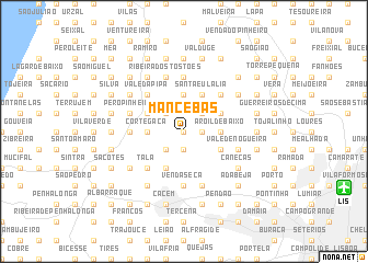
Mancebas (Lisboa, Portugal)Mancebas is a town in the Lisboa region of Portugal. An overview map of the region around Mancebas is displayed below.
regional and 3d topo map of Mancebas, Portugal ::
nearby GPS traces from timatio ::
Mancebas airports ::
The nearest airport is LIS - Lisbon Lisboa, located 14.0 km south east of Mancebas.
Other airports nearby include FAO - Faro (232.8 km south east), Nearby towns ::
Olelas (0.0km north) //
Almargem (1.4km east) //
Aroil de Cima (1.4km east) //
Vale de Lobos (1.9km south) //
Almornos (1.4km east) //
Santa Cruz (2.3km south west) //
Sabugo (2.3km south west) //
Machados (2.3km north east) //
Ormal (2.3km north west) //
Alveijar (2.9km east) //
Aroil de Baixo (2.9km east) //
Cortegaça (2.9km west) //
Alfouvar de Baixo (3.7km north) //
Dona Maria (3.4km south east) //
Alvogas (3.4km north east) //
Quinta do Malhapão (4.0km south) //
Santa Eulália (4.0km north) //
Mortena (3.4km north west) //
Tala (4.7km south west) //
Casa de Saúde do Telhal (4.7km south west) //
Mercês (4.7km south west) //
Barata (4.7km south west) //
Pedregais (4.7km south west) //
Covas de Ferro (4.7km north east) //
Monfirre (4.7km north east) //
Vale da Pipa (4.7km north west) //
Maceira (4.7km north west) //
Negrais (5.6km north) //
Covas (5.6km north) //
[all distances 'as the bird flies' and approximate]  Places with similar names to Mancebas, Portugal :: Disclaimer :: Information on this page comes without warranty of any kind |
||
|
Where is Mancebas? Elevation and coordinates ::
Latitude (lat): 38°50'0"N Longitude (lon): 9°17'0"W
Elevation (approx.): 256m (map arrows pan, magnifying glasses zoom) |
||
|
Visiting Mancebas? Hotel/Accommodation ::
Book a hotel in Mancebas Travel Guide ::
Buy a travel guide for Portugal rental cars ::
car rental offers GPS waypoint ::
download a GPX waypoint (PoI) of Mancebas for your GPS receiver
|
||