|
search place name
|
||
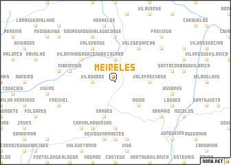
Meireles (Bragança, Portugal)Meireles is a town in the Bragança region of Portugal. An overview map of the region around Meireles is displayed below.
regional and 3d topo map of Meireles, Portugal ::
Meireles airports ::
The nearest airport is VRL - Vila Real, located 47.1 km west of Meireles.
Other airports nearby include BGC - Braganca (68.2 km north east), OPO - Porto (127.4 km west), SLM - Salamanca (146.6 km east), VGO - Vigo (156.0 km north west), Nearby towns ::
Cachão (3.7km north) //
Vilas Boas (2.8km west) //
Róios (4.6km south east) //
Vale Frechoso (4.2km east) //
Samões (5.7km south) //
Vilarinho das Azenhas (5.6km north west) //
Vale Verde (6.2km north west) //
Vale de Sancha (6.2km north east) //
Arco (7.4km south) //
Frechas (7.4km north) //
Ribeirinha (5.9km west) //
Barcel (5.9km west) //
São Pedro de Vale do Conde (7.9km north) //
Carvalho de Egas (7.9km south) //
Macedinho (7.9km north east) //
Candoso (8.5km south west) //
Sampaio (7.9km south east) //
Freixeda (9.3km north east) //
[all distances 'as the bird flies' and approximate]  Places with similar names to Meireles, Portugal ::
// Morles (DE)
// Morlesau (DE)
// Maureles (PT)
// Merlães (PT)
// Mourelos (PT)
// Mourelos (PT)
// María Luisa (CU)
// María Luisa (CU)
// María Luisa (CU)
// María Luisa (CU)
Disclaimer :: Information on this page comes without warranty of any kind |
||
|
Where is Meireles? Elevation and coordinates ::
Latitude (lat): 41°21'0"N Longitude (lon): 7°10'0"W
Elevation (approx.): 420m (map arrows pan, magnifying glasses zoom) |
||
|
Visiting Meireles? Hotel/Accommodation ::
Book a hotel in Meireles Travel Guide ::
Buy a travel guide for Portugal rental cars ::
car rental offers GPS waypoint ::
download a GPX waypoint (PoI) of Meireles for your GPS receiver
|
||