|
search place name
|
||
Moita (Leiria, Portugal)Moita is a town in the Leiria region of Portugal. An overview map of the region around Moita is displayed below.
regional and 3d topo map of Moita, Portugal ::

Moita airports ::
The nearest airport is LIS - Lisbon Lisboa, located 91.5 km south of Moita.
Other airports nearby include OPO - Porto (185.2 km north), VRL - Vila Real (216.0 km north east), Nearby towns ::
Valado de Frades (1.9km south) //
Fanhais (2.3km north east) //
Bárrio (3.7km south) //
Pataeiro (3.4km south east) //
Casalinho (3.4km south east) //
Maiorga (3.4km south east) //
Fervença (4.7km south east) //
Sítio (4.3km west) //
Nazaré (4.3km west) //
Póvoa (4.3km east) //
Pederneira (4.3km west) //
Fanheiro (5.6km south) //
Casais (5.6km south) //
Pinhal (5.6km south) //
Cumeira (5.6km south) //
Vale de Amieiro (4.7km south east) //
Ribeira do Pereiro (4.7km north east) //
Vestiaria (5.7km south) //
Ferraria (5.7km north east) //
Voubam de Baixo (5.7km north east) //
Casal do Mota (5.7km south west) //
Bemposta (5.7km south east) //
Cela Velha (6.3km south west) //
Alcobaça (6.3km south east) //
Alqueidão (5.7km east) //
Cos (5.7km east) //
Cela (7.5km south) //
Pataias (7.5km north) //
Mendalvo (7.5km south) //
[all distances 'as the bird flies' and approximate] 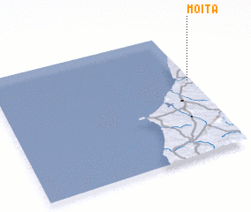 Places with similar names to Moita, Portugal ::
Disclaimer :: Information on this page comes without warranty of any kind |
||
|
Where is Moita? Elevation and coordinates ::
Latitude (lat): 39°36'0"N Longitude (lon): 9°1'0"W
Elevation (approx.): 67m (map arrows pan, magnifying glasses zoom) |
||
|
Visiting Moita? Hotel/Accommodation ::
Book a hotel in Moita Travel Guide ::
Buy a travel guide for Portugal rental cars ::
car rental offers GPS waypoint ::
download a GPX waypoint (PoI) of Moita for your GPS receiver
|
||