|
search place name
|
||
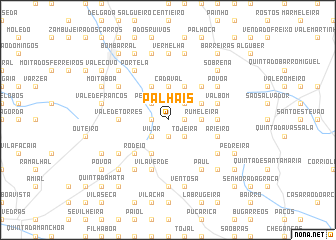
Palhais (Lisboa, Portugal)Palhais is a town in the Lisboa region of Portugal. An overview map of the region around Palhais is displayed below.
regional and 3d topo map of Palhais, Portugal ::
Palhais airports ::
The nearest airport is LIS - Lisbon Lisboa, located 46.6 km south of Palhais.
Nearby towns ::
Correeira (1.4km east) //
Quinta do Gradil (1.4km west) //
Vila Nova (1.4km east) //
Ventosa (1.4km east) //
Avenal (1.9km south) //
Boiça de Baixo (2.3km north east) //
Pêro Moniz (2.3km north west) //
Martim Joanes (2.3km north west) //
Chão de Sapo (2.3km north east) //
Lamas (2.3km north east) //
Vilar (2.3km south west) //
Pereiro (2.3km south east) //
Tojeira (2.3km south east) //
Cadaval (3.7km north) //
Pragança (2.9km east) //
Rumeleira (2.9km east) //
Entroncamento (4.0km north) //
Adão Lobo (4.0km north) //
Casalinho (3.4km north east) //
Boiça de Cima (3.4km north east) //
Casa da Feteira (4.0km south) //
Rechaldeira (4.0km south) //
Murteira (4.7km north east) //
Rodeio (4.7km south west) //
Charco (4.3km east) //
Vale de Torres (4.3km west) //
Rocha Forte (4.7km north east) //
Valbom (4.7km north east) //
Arieiro (4.7km south east) //
[all distances 'as the bird flies' and approximate]  Places with similar names to Palhais, Portugal ::
Disclaimer :: Information on this page comes without warranty of any kind |
||
|
Where is Palhais? Elevation and coordinates ::
Latitude (lat): 39°12'0"N Longitude (lon): 9°6'0"W
Elevation (approx.): 88m (map arrows pan, magnifying glasses zoom) |
||
|
Visiting Palhais? Hotel/Accommodation ::
Book a hotel in Palhais Travel Guide ::
Buy a travel guide for Portugal rental cars ::
car rental offers GPS waypoint ::
download a GPX waypoint (PoI) of Palhais for your GPS receiver
|
||