|
search place name
|
||
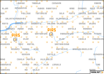
Pias (Viana do Castelo, Portugal)Pias is a town in the Viana do Castelo region of Portugal. An overview map of the region around Pias is displayed below.
regional and 3d topo map of Pias, Portugal ::
Pias airports ::
The nearest airport is VGO - Vigo, located 29.9 km north west of Pias.
Other airports nearby include OPO - Porto (90.7 km south), SCQ - Santiago (95.9 km north), VRL - Vila Real (100.8 km south east), BGC - Braganca (140.4 km east), Nearby towns ::
Marrajós (0.0km north) //
Vila Martins (0.0km north) //
Oveiras (0.0km north) //
Merufe (1.9km south) //
Serra (1.9km south) //
Trogal (1.4km east) //
Cernadas (1.9km south) //
Cotinho (1.4km east) //
Paradela (1.9km north) //
Segude (1.9km north) //
Quinteiro (1.4km west) //
Pica (1.4km west) //
Merim (1.4km west) //
Ribeiro (1.4km west) //
Pereiras (1.4km west) //
Pretos (1.4km west) //
Fornelos (2.3km south east) //
Tangil (2.3km south east) //
Azevedo (2.3km south west) //
Poldras (2.3km north west) //
Granja de Baixo (3.7km south) //
Valinha (3.7km north) //
Ceivães (3.7km north) //
Moujuzão (3.7km north) //
Moucheira (3.7km north) //
Santo André (2.8km west) //
Guimil (2.8km west) //
Vilar (3.3km south east) //
Lameira (3.3km south east) //
[all distances 'as the bird flies' and approximate]  Places with similar names to Pias, Portugal ::
Disclaimer :: Information on this page comes without warranty of any kind |
||
|
Where is Pias? Elevation and coordinates ::
Latitude (lat): 42°2'0"N Longitude (lon): 8°23'0"W
Elevation (approx.): 54m (map arrows pan, magnifying glasses zoom) |
||
|
Visiting Pias? Hotel/Accommodation ::
Book a hotel in Pias Travel Guide ::
Buy a travel guide for Portugal rental cars ::
car rental offers GPS waypoint ::
download a GPX waypoint (PoI) of Pias for your GPS receiver
|
||