|
search place name
|
||
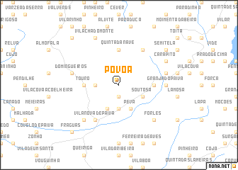
Póvoa (Viseu, Portugal)Póvoa is a town in the Viseu region of Portugal. An overview map of the region around Póvoa is displayed below.
regional and 3d topo map of Póvoa, Portugal ::
Póvoa airports ::
The nearest airport is VRL - Vila Real, located 41.6 km north of Póvoa.
Other airports nearby include OPO - Porto (91.1 km north west), BGC - Braganca (135.0 km north east), VGO - Vigo (166.9 km north west), SCQ - Santiago (229.5 km north), Nearby towns ::
São Martinho (1.9km south) //
Alhais (3.7km south) //
Cerdeira (2.8km west) //
Peva (4.0km south) //
Alhais de Cima (4.0km south) //
Soutosa (3.4km south east) //
Touro (4.2km west) //
Ariz (4.2km east) //
Quinta da Nave (5.6km north) //
Vila Nova de Paiva (6.2km south west) //
Currais de Gado (6.2km north east) //
Granja do Paiva (5.6km east) //
Domingueiros (5.9km west) //
Pêra Velha (5.9km east) //
Segões (7.0km south west) //
Forles (7.0km south east) //
Vila Chã do Monte (7.9km north) //
Carapito (6.7km north east) //
Semitela (7.9km north east) //
Fráguas (9.3km south west) //
Bustelo (9.3km north west) //
[all distances 'as the bird flies' and approximate] 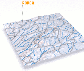 Places with similar names to Póvoa, Portugal ::
Disclaimer :: Information on this page comes without warranty of any kind |
||
|
Where is Póvoa? Elevation and coordinates ::
Latitude (lat): 40°54'0"N Longitude (lon): 7°42'0"W
Elevation (approx.): 874m (map arrows pan, magnifying glasses zoom) |
||
|
Visiting Póvoa? Hotel/Accommodation ::
Book a hotel in Póvoa Travel Guide ::
Buy a travel guide for Portugal rental cars ::
car rental offers GPS waypoint ::
download a GPX waypoint (PoI) of Póvoa for your GPS receiver
|
||