|
search place name
|
||
Ramalhal (Leiria, Portugal)Ramalhal is a town in the Leiria region of Portugal. An overview map of the region around Ramalhal is displayed below.
regional and 3d topo map of Ramalhal, Portugal ::

Ramalhal airports ::
The nearest airport is LIS - Lisbon Lisboa, located 128.0 km south west of Ramalhal.
Other airports nearby include BJZ - Badajoz Talavera La Real (164.9 km south east), OPO - Porto (166.6 km north), VRL - Vila Real (176.1 km north), Nearby towns ::
Farroeira (0.0km north) //
Relvas (1.4km west) //
Rego da Murta (1.4km east) //
Pereiro (1.9km south) //
Cortiça (2.3km north west) //
Mosqueiro (2.3km north east) //
Telhadas (2.3km south east) //
Pussos (3.7km north) //
Daporta (3.7km south) //
Vila Verde (3.7km south) //
Feteiras (4.0km north) //
Loureira (3.4km north west) //
Jordões (4.0km north) //
Cabaços (4.0km north) //
Ave Casta (3.4km south west) //
Carvalhal de São Bento (3.4km north east) //
Menexas (3.4km south east) //
Areias (4.0km south) //
Zambujal (4.7km north west) //
Mata de Cima (4.7km north west) //
Boca da Mata (4.7km north west) //
Portela do Brás (4.7km north east) //
Milheiros (4.7km south west) //
Gontijas (4.7km south east) //
Aldeia dos Gagos (4.7km south east) //
Seiceira (5.6km north) //
Marques (4.3km west) //
Portela de Vila Verde (5.6km south) //
Fonte da Laje (5.6km south) //
[all distances 'as the bird flies' and approximate] 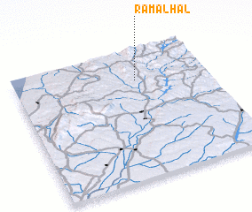 Places with similar names to Ramalhal, Portugal ::
// Ramalhal (PT)
Disclaimer :: Information on this page comes without warranty of any kind |
||
|
Where is Ramalhal? Elevation and coordinates ::
Latitude (lat): 39°46'0"N Longitude (lon): 8°22'0"W
Elevation (approx.): 210m (map arrows pan, magnifying glasses zoom) |
||
|
Visiting Ramalhal? Hotel/Accommodation ::
Book a hotel in Ramalhal Travel Guide ::
Buy a travel guide for Portugal rental cars ::
car rental offers GPS waypoint ::
download a GPX waypoint (PoI) of Ramalhal for your GPS receiver
|
||