|
search place name
|
||
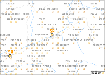
Sá (Viana do Castelo, Portugal)Sá is a town in the Viana do Castelo region of Portugal. An overview map of the region around Sá is displayed below.
regional and 3d topo map of Sá, Portugal ::
Sá airports ::
The nearest airport is VGO - Vigo, located 35.6 km west of Sá.
Other airports nearby include SCQ - Santiago (86.3 km north), VRL - Vila Real (104.0 km south east), OPO - Porto (105.7 km south), BGC - Braganca (128.8 km east), Nearby towns ::
Vinhas (0.0km north) //
Merelhe (0.0km north) //
Pedreira (0.0km north) //
Viladraque (1.9km south) //
Ribera (1.4km west) //
Portela do Couto (1.4km west) //
Gondufe (1.4km west) //
Marga (1.4km east) //
Porta (1.4km east) //
Ramo (1.4km east) //
São Gregório (1.4km east) //
Carvão (1.4km east) //
Cristoval (1.4km east) //
Outeiro (1.4km east) //
Paços (1.4km east) //
Beleco (1.4km east) //
Crecíente (1.9km north) //
Quintela (1.9km north) //
Cortinhal (2.3km south west) //
Vale (2.3km south west) //
Sobreiro (2.3km south east) //
Freijo (2.3km north east) //
Cevide (2.3km north east) //
Casais (2.3km north east) //
Ladrongueira (3.7km south) //
Jugaria (3.7km south) //
Fiães (3.7km south) //
Cequelinos (2.7km west) //
Albeos (2.7km west) //
[all distances 'as the bird flies' and approximate]  Places with similar names to Sá, Portugal ::
Disclaimer :: Information on this page comes without warranty of any kind |
||
|
Where is Sá? Elevation and coordinates ::
Latitude (lat): 42°8'0"N Longitude (lon): 8°13'0"W
Elevation (approx.): 112m (map arrows pan, magnifying glasses zoom) |
||
|
Visiting Sá? Hotel/Accommodation ::
Book a hotel in Sá Travel Guide ::
Buy a travel guide for Portugal rental cars ::
car rental offers GPS waypoint ::
download a GPX waypoint (PoI) of Sá for your GPS receiver
|
||