|
search place name
|
||
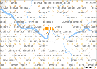
Sante (Porto, Portugal)Sante is a town in the Porto region of Portugal. An overview map of the region around Sante is displayed below.
regional and 3d topo map of Sante, Portugal ::
Sante airports ::
The nearest airport is OPO - Porto, located 31.3 km north west of Sante.
Other airports nearby include VRL - Vila Real (63.5 km north east), VGO - Vigo (132.4 km north), BGC - Braganca (168.7 km north east), SCQ - Santiago (205.1 km north), Nearby towns ::
Lomba (0.0km north) //
Medas (1.4km west) //
Carvalhos (1.4km west) //
Pé de Mouro (1.9km south) //
Farrapa (1.9km south) //
Areja (1.4km east) //
São Tiago (1.9km north) //
Sobrido (2.3km north west) //
Melres (2.3km north east) //
Quintãs (2.3km north east) //
Porto Carvoeiro (2.8km west) //
Branzelo (3.7km north) //
Moreira (2.8km east) //
Pedorido (2.8km east) //
Inha (4.0km south) //
Vale Cova (4.0km south) //
Brandião (4.0km north) //
Mosteirô (3.4km south west) //
Vila Cova (3.4km north west) //
Pombal (3.4km north west) //
Picão (3.4km south east) //
Póvoa (3.4km south east) //
Vilarinho (3.4km north east) //
Sousanil (4.6km south west) //
Louzado (4.6km south west) //
Rebordelo (5.6km south) //
Portelinha (4.2km west) //
Rio Mau (4.2km east) //
Serralva (5.7km south) //
[all distances 'as the bird flies' and approximate]  Places with similar names to Sante, Portugal ::
Disclaimer :: Information on this page comes without warranty of any kind |
||
|
Where is Sante? Elevation and coordinates ::
Latitude (lat): 41°3'0"N Longitude (lon): 8°25'0"W
Elevation (approx.): 63m (map arrows pan, magnifying glasses zoom) |
||
|
Visiting Sante? Hotel/Accommodation ::
Book a hotel in Sante Travel Guide ::
Buy a travel guide for Portugal rental cars ::
car rental offers GPS waypoint ::
download a GPX waypoint (PoI) of Sante for your GPS receiver
|
||