|
search place name
|
||
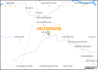
Vale de guiso (Setúbal, Portugal)Vale de guiso is a town in the Setúbal region of Portugal. An overview map of the region around Vale de guiso is displayed below.
regional and 3d topo map of Vale de guiso, Portugal ::
Vale de guiso airports ::
The nearest airport is LIS - Lisbon Lisboa, located 79.1 km north west of Vale de guiso.
Other airports nearby include FAO - Faro (149.4 km south), BJZ - Badajoz Talavera La Real (157.6 km north east), Nearby towns ::
Arouca (0.0km north) //
Arez (1.5km west) //
Porches (1.5km east) //
Vale de Maceira (4.0km north) //
Monte de Alfevre do Mar (4.7km north east) //
Monte das Obras (5.7km north) //
Barrosinha (7.6km north) //
Parchanas (6.1km east) //
Porto do Rei (6.1km east) //
Alcácer do Sal (8.0km north) //
Lezíria (8.0km north) //
[all distances 'as the bird flies' and approximate] 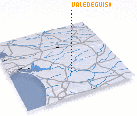 Places with similar names to Vale de guiso, Portugal ::
// Valdegas (PT)
// Vale de Couce (PT)
// Falatycze (PL)
// Valea de Casă (RO)
// Valdecasa (ES)
// Vall de Uxó (ES)
// Villa de Cos (MX)
// Villedoux (FR)
// Val-de-Cães (BR)
// Villa Tucci (IT)
Disclaimer :: Information on this page comes without warranty of any kind |
||
|
Where is Vale de guiso? Elevation and coordinates ::
Latitude (lat): 38°18'0"N Longitude (lon): 8°28'0"W
Elevation (approx.): 5m (map arrows pan, magnifying glasses zoom) |
||
|
Visiting Vale de guiso? Hotel/Accommodation ::
Book a hotel in Vale de guiso Travel Guide ::
Buy a travel guide for Portugal rental cars ::
car rental offers GPS waypoint ::
download a GPX waypoint (PoI) of Vale de guiso for your GPS receiver
|
||