|
search place name
|
||
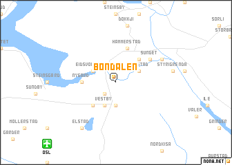
Bøndalen (Akershus, Norway)Bøndalen is a town in the Akershus region of Norway. An overview map of the region around Bøndalen is displayed below.
regional and 3d topo map of Bøndalen, Norway ::
Bøndalen airports ::
The nearest airport is OSL - Oslo Gardermoen, located 11.4 km south west of Bøndalen.
Other airports nearby include VDB - Fagernes Leirin (132.6 km north west), TRF - Torp (133.1 km south west), SKE - Skien Geiteryggen (153.0 km south west), THN - Trollhattan Vanersborg (228.4 km south), Nearby towns ::
Råholt (2.1km south west) //
Dal (3.7km south) //
Eidsvoll Verk (2.6km north west) //
Finnstad (2.6km north east) //
Vestby (3.8km south) //
Sesvoll (4.1km south west) //
Eidsvoll (4.1km north east) //
Nygard (2.8km west) //
Hammerstad (5.6km north) //
Sundet (4.6km north east) //
Elstad (5.2km north east) //
Elstad (7.9km south) //
[all distances 'as the bird flies' and approximate]  Places with similar names to Bøndalen, Norway ::
// Bantilan (PH)
// Bantulin (PH)
// Bantolinao (PH)
// Bantolinao (PH)
// Bantolinao (PH)
// Bantolinao (PH)
// Bantolinaw (PH)
// Bantulan (PH)
// Bintoulan (PH)
// Bondolan (PH)
Disclaimer :: Information on this page comes without warranty of any kind |
||
|
Where is Bøndalen? Elevation and coordinates ::
Latitude (lat): 60°17'0"N Longitude (lon): 11°12'0"E
(map arrows pan, magnifying glasses zoom) |
||
|
Visiting Bøndalen? Hotel/Accommodation ::
Book a hotel in Bøndalen Travel Guide ::
Buy a travel guide for Norway rental cars ::
car rental offers GPS waypoint ::
download a GPX waypoint (PoI) of Bøndalen for your GPS receiver
|
||