|
search place name
|
||
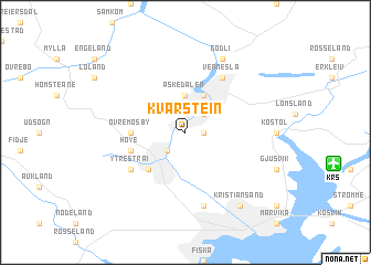
Kvarstein (Vest-Agder, Norway)Kvarstein is a town in the Vest-Agder region of Norway. An overview map of the region around Kvarstein is displayed below.
regional and 3d topo map of Kvarstein, Norway ::
Kvarstein airports ::
The nearest airport is KRS - Kristiansand Kjevik, located 8.6 km east of Kvarstein.
Other airports nearby include FAN - Lista (79.3 km west), TED - Thisted (137.3 km south), SKE - Skien Geiteryggen (141.5 km north east), AAL - Aalborg (170.2 km south east), Nearby towns ::
Vigelandsbruk (1.0km east) //
Flaten (2.1km south west) //
Vigeland (2.1km north east) //
Askedalen (3.7km north) //
Hunsfoss (3.8km north) //
Aukland (4.2km south west) //
Øvre Mosby (2.9km west) //
Høye (3.5km south west) //
Ytre Strai (4.7km south west) //
Vennesla (5.9km north) //
Dalane (7.5km south) //
Godli (7.7km north) //
Kristiansand (8.0km south) //
Eg (8.0km south) //
[all distances 'as the bird flies' and approximate]  Places with similar names to Kvarstein, Norway ::
// Kafr aş Şayyādīn (EG)
// Kafr as Sūdān (EG)
// Kafr az Zaytūn (EG)
// Gverezdno (RU)
// Gverezdno (RU)
// Coverstone (US)
// Gverzdon' (RU)
// Kafr Sa‘dūn (EG)
Disclaimer :: Information on this page comes without warranty of any kind |
||
|
Where is Kvarstein? Elevation and coordinates ::
Latitude (lat): 58°14'0"N Longitude (lon): 7°57'0"E
Elevation (approx.): 150m (map arrows pan, magnifying glasses zoom) |
||
|
Visiting Kvarstein? Hotel/Accommodation ::
Book a hotel in Kvarstein Travel Guide ::
Buy a travel guide for Norway rental cars ::
car rental offers GPS waypoint ::
download a GPX waypoint (PoI) of Kvarstein for your GPS receiver
|
||