|
search place name
|
||
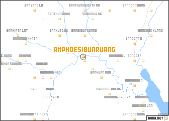
Amphoe Si Bun Ruang (Udon Thani, Thailand)Amphoe Si Bun Ruang is a town in the Udon Thani region of Thailand. An overview map of the region around Amphoe Si Bun Ruang is displayed below.
regional and 3d topo map of Amphoe Si Bun Ruang, Thailand ::
Amphoe Si Bun Ruang airports ::
The nearest airport is UTH - Udon Thani, located 78.6 km north east of Amphoe Si Bun Ruang.
Other airports nearby include LOE - Loei (84.5 km north west), VTE - Vientiane Wattay Intl (126.3 km north), SNO - Sakon Nakhon (200.2 km east), PHS - Phitsanulok (212.1 km west), Nearby towns ::
Ban Khat That (NaNkm north) //
Ban Huai Thap Khwai (NaNkm north) //
Ban Sa-at (2.6km south east) //
Ban Huai Huak (2.6km north east) //
Ban Khok Lam (4.0km north west) //
Ban Hua Na Mo (5.1km south east) //
Ban Si Bun Ruang (5.6km north) //
Ban Nong-u (7.1km east) //
Ban Kut Duk (7.7km north west) //
Ban Wang Mon (8.0km south west) //
Ban Nong Waeng (9.1km south east) //
Ban Na Fai (10.3km south east) //
[all distances 'as the bird flies' and approximate]  Places with similar names to Amphoe Si Bun Ruang, Thailand :: Disclaimer :: Information on this page comes without warranty of any kind |
||
|
Where is Amphoe Si Bun Ruang? Elevation and coordinates ::
Latitude (lat): 16°53'0"N Longitude (lon): 102°16'0"E
Elevation (approx.): 197m (map arrows pan, magnifying glasses zoom) |
||
|
Visiting Amphoe Si Bun Ruang? Hotel/Accommodation ::
Book a hotel in Amphoe Si Bun Ruang Travel Guide ::
Buy a travel guide for Thailand rental cars ::
car rental offers GPS waypoint ::
download a GPX waypoint (PoI) of Amphoe Si Bun Ruang for your GPS receiver
|
||