|
search place name
|
||
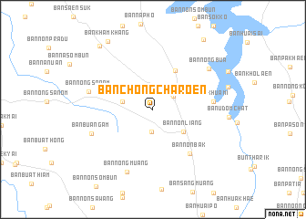
Ban Chong Charoen (Ubon Ratchathani, Thailand)Ban Chong Charoen is a town in the Ubon Ratchathani region of Thailand. An overview map of the region around Ban Chong Charoen is displayed below.
regional and 3d topo map of Ban Chong Charoen, Thailand ::
Ban Chong Charoen airports ::
The nearest airport is PKZ - Pakse, located 61.9 km north east of Ban Chong Charoen.
Other airports nearby include ZVK - Savannakhet (200.2 km north), REP - Siem-reap Siem Reap (224.2 km south west), Nearby towns ::
Ban Nong Sano (2.8km south) //
Ban Maet (2.9km north east) //
Ban Na Pho (3.7km west) //
Ban Maet (3.7km west) //
Ban Non Liang (4.5km south east) //
Ban Na Khaen (5.5km north east) //
Ban Non Bak (7.0km south east) //
Ban Khua Mi (7.2km east) //
Ban Hin Lat Tham (7.2km east) //
Ban Huai Sai (7.2km east) //
Ban Kaeng Yang (7.2km east) //
Ban Kho Laen (7.2km east) //
Ban Khon Paen (7.2km east) //
Ban Bua Ngam (7.8km west) //
Ban Nong Sanom (7.9km west) //
Ban Nong Muang (8.2km south) //
Ban Nong Bua (8.3km north east) //
Ban Kham Khang (9.9km north west) //
Ban Kham Khang (10.1km north west) //
Ban Hat Sai Khuh (10.4km north east) //
[all distances 'as the bird flies' and approximate]  Places with similar names to Ban Chong Charoen, Thailand :: Disclaimer :: Information on this page comes without warranty of any kind |
||
|
Where is Ban Chong Charoen? Elevation and coordinates ::
Latitude (lat): 14°49'30"N Longitude (lon): 105°18'0"E
Elevation (approx.): 173m (map arrows pan, magnifying glasses zoom) |
||
|
Visiting Ban Chong Charoen? Hotel/Accommodation ::
Book a hotel in Ban Chong Charoen Travel Guide ::
Buy a travel guide for Thailand rental cars ::
car rental offers GPS waypoint ::
download a GPX waypoint (PoI) of Ban Chong Charoen for your GPS receiver
|
||