|
search place name
|
||
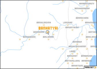
Ban Hat Yai (Chumphon, Thailand)Ban Hat Yai is a town in the Chumphon region of Thailand. An overview map of the region around Ban Hat Yai is displayed below.
regional and 3d topo map of Ban Hat Yai, Thailand ::
Ban Hat Yai airports ::
The nearest airport is NST - Nakhon Si Thammarat Cha Ian, located 191.3 km south east of Ban Hat Yai.
Other airports nearby include HKT - Phuket Intl (213.1 km south), Nearby towns ::
Ban Laem Pai (1.9km south) //
Ban Hat Yai (2) (1.8km east) //
Ban Phan Rai (3.7km west) //
Ban Khlong Krim (4.1km north west) //
Ban Pang Wan (1) (7.5km west) //
Ban Khao Chok (7.8km south east) //
Lang Suan (8.2km north east) //
[all distances 'as the bird flies' and approximate] 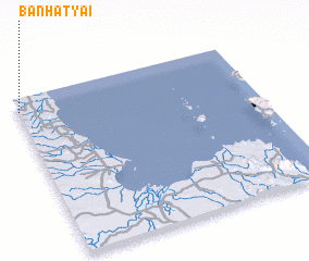 Places with similar names to Ban Hat Yai, Thailand ::
// Ban Hat Yai (TH)
// Ban Hat Yao (TH)
Disclaimer :: Information on this page comes without warranty of any kind |
||
|
Where is Ban Hat Yai? Elevation and coordinates ::
Latitude (lat): 9°55'0"N Longitude (lon): 99°0'0"E
Elevation (approx.): 23m (map arrows pan, magnifying glasses zoom) |
||
|
Visiting Ban Hat Yai? Hotel/Accommodation ::
Book a hotel in Ban Hat Yai Travel Guide ::
Buy a travel guide for Thailand rental cars ::
car rental offers GPS waypoint ::
download a GPX waypoint (PoI) of Ban Hat Yai for your GPS receiver
|
||