|
search place name
|
||
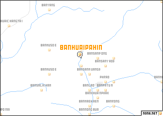
Ban Huai Pa Hin (Phayao, Thailand)Ban Huai Pa Hin is a town in the Phayao region of Thailand. An overview map of the region around Ban Huai Pa Hin is displayed below.
regional and 3d topo map of Ban Huai Pa Hin, Thailand ::
Ban Huai Pa Hin airports ::
The nearest airport is MOG - Mong Hsat, located 122.1 km north of Ban Huai Pa Hin.
Other airports nearby include LPT - Lampang (131.7 km south), THL - Tachilek Tachileik (142.9 km north east), PRH - Phrae (176.9 km south east), KET - Kengtung (214.4 km north), Nearby towns ::
Ban Huai San (1.9km north) //
Ban Wat (1.9km south) //
Ban San Pong (3.5km east) //
Ban Kham Sum Nok (3.5km east) //
Ban Pa Lan (3.7km south) //
Ban Pa Hin (3.7km south) //
Ban Nong Hai (3.7km south) //
Ban San Muang (1) (4.1km south east) //
Ban Sali Kham (4.1km south east) //
Ban San Yao (1) (5.6km east) //
Ban Lao (7.0km east) //
Ban Musoe (7.2km west) //
Amphoe Phrao (7.6km south) //
Ban Lao (7.6km south) //
Ban Nam Phrae (7.6km south) //
Phrao (7.6km south east) //
Ban Mo (8.2km south east) //
Ban Musoe (7.9km south west) //
Ban Pa Ha (8.9km south east) //
Ban Ton Hung (8.9km south east) //
Ban Pa Tum (9.1km south east) //
[all distances 'as the bird flies' and approximate]  Places with similar names to Ban Huai Pa Hin, Thailand ::
// Ban Houeï Pahine (LA)
Disclaimer :: Information on this page comes without warranty of any kind |
||
|
Where is Ban Huai Pa Hin? Elevation and coordinates ::
Latitude (lat): 19°25'0"N Longitude (lon): 99°10'0"E
Elevation (approx.): 537m (map arrows pan, magnifying glasses zoom) |
||
|
Visiting Ban Huai Pa Hin? Hotel/Accommodation ::
Book a hotel in Ban Huai Pa Hin Travel Guide ::
Buy a travel guide for Thailand rental cars ::
car rental offers GPS waypoint ::
download a GPX waypoint (PoI) of Ban Huai Pa Hin for your GPS receiver
|
||