|
search place name
|
||
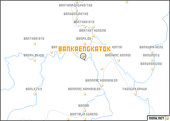
Ban Kaeng Katok (Kanchanaburi, Thailand)Ban Kaeng Katok is a town in the Kanchanaburi region of Thailand. An overview map of the region around Ban Kaeng Katok is displayed below.
regional and 3d topo map of Ban Kaeng Katok, Thailand ::
Ban Kaeng Katok airports ::
The nearest airport is PHS - Phitsanulok, located 288.3 km north east of Ban Kaeng Katok.
Nearby towns ::
Ban Don Khrong (2.6km north west) //
Ban Pilok (3.7km north) //
Ban Pracham Mai Lang (4.0km south east) //
Ban Pracham Mai Lang (4.0km south east) //
Ban Rai Pa (5.7km west) //
Ban Tha Thung Na (5.8km north) //
Ban Nam Chon Yai (5.7km east) //
Ban Pracham Mai Bon (6.6km south east) //
Ban Nam Chon Noi (7.2km east) //
Ban Tha Mayo (7.4km north) //
Ban Nam Chon Noi (7.4km south) //
Ban Pracham Mai Bon (7.4km south) //
Ban Nam Chon Yai (7.4km south) //
Ban Le The (7.4km west) //
Ban Tha Madua (7.6km north) //
[all distances 'as the bird flies' and approximate]  Places with similar names to Ban Kaeng Katok, Thailand :: Disclaimer :: Information on this page comes without warranty of any kind |
||
|
Where is Ban Kaeng Katok? Elevation and coordinates ::
Latitude (lat): 14°48'0"N Longitude (lon): 98°32'0"E
Elevation (approx.): 157m (map arrows pan, magnifying glasses zoom) |
||
|
Visiting Ban Kaeng Katok? Hotel/Accommodation ::
Book a hotel in Ban Kaeng Katok Travel Guide ::
Buy a travel guide for Thailand rental cars ::
car rental offers GPS waypoint ::
download a GPX waypoint (PoI) of Ban Kaeng Katok for your GPS receiver
|
||