|
search place name
|
||
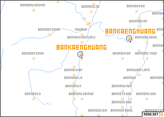
Ban Kaeng Muang (Thailand)Ban Kaeng Muang is a town in Thailand. An overview map of the region around Ban Kaeng Muang is displayed below.
regional and 3d topo map of Ban Kaeng Muang, Thailand ::
Ban Kaeng Muang airports ::
The nearest airport is LOE - Loei, located 69.6 km east of Ban Kaeng Muang.
Other airports nearby include PHS - Phitsanulok (110.5 km south west), PRH - Phrae (123.0 km north west), VTE - Vientiane Wattay Intl (170.2 km east), UTH - Udon Thani (183.0 km east), Nearby towns ::
Ban Huai Lat (0.0km north) //
Ban Kaeng Dao (0.0km north) //
Ban Lat (1.9km north) //
Ban Na Thon (2.6km south west) //
Ban Na Phung (2.6km south west) //
Ban Na Khaen Yong (3.7km north) //
Ban Na Chan (4.1km south west) //
Ban Na Haeo (5.6km north) //
Na Haeo (5.6km north) //
Ban Hua Dan (5.8km south) //
Ban Na Mala (5.8km south) //
Ban Na Pun (7.6km south) //
Ban Muang Phrae (7.6km north) //
Ban Phon Prasat (7.6km north) //
Ban Na Pho (7.6km north) //
Ban Huai Lat (7.7km north east) //
Ban Muangphra (8.1km north) //
Ban Natha (8.4km north) //
Ban Saeng Pha (9.0km north west) //
[all distances 'as the bird flies' and approximate]  Places with similar names to Ban Kaeng Muang, Thailand ::
// Ban Kaeng Muang (TH)
// Ban Kaeng Muang (TH)
// Ban Kaeng Muang (TH)
// Ban Kaeng Muang (TH)
// Ban Kangmông (LA)
// Ban Kangmuang (LA)
// Ban Kangmuang (LA)
// Bản Cung Mường (VN)
Disclaimer :: Information on this page comes without warranty of any kind |
||
|
Where is Ban Kaeng Muang? Elevation and coordinates ::
Latitude (lat): 17°26'0"N Longitude (lon): 101°4'0"E
Elevation (approx.): 648m (map arrows pan, magnifying glasses zoom) |
||
|
Visiting Ban Kaeng Muang? Hotel/Accommodation ::
Book a hotel in Ban Kaeng Muang Travel Guide ::
Buy a travel guide for Thailand rental cars ::
car rental offers GPS waypoint ::
download a GPX waypoint (PoI) of Ban Kaeng Muang for your GPS receiver
|
||