|
search place name
|
||
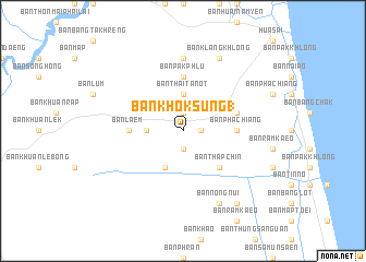
Ban Khok Sung (1) (Nakhon Si Thammarat, Thailand)Ban Khok Sung (1) is a town in the Nakhon Si Thammarat region of Thailand. An overview map of the region around Ban Khok Sung (1) is displayed below.
regional and 3d topo map of Ban Khok Sung (1), Thailand ::
Ban Khok Sung (1) airports ::
The nearest airport is NST - Nakhon Si Thammarat Cha Ian, located 64.4 km north west of Ban Khok Sung (1).
Other airports nearby include TST - Trang (82.2 km south west), HDY - Songkhla Hat Yai Intl (114.1 km south), PAN - Pattani (165.2 km south east), LGK - Pulau Langkawi Intl (187.1 km south), Nearby towns ::
Ban Khao Phang Krai (1.8km east) //
Ban Luk (1.9km south) //
Ban Laem (1.9km north) //
Ban Thai Tanot (3.7km north) //
Ban Khuan Le Tang (3.7km west) //
Ban Khuan Thale Mong (4.1km south west) //
Ban Thap Chin (5.2km south east) //
Ban Pha Chiang (5.5km east) //
Ban Pak Phlu (5.6km north) //
Ban I Mon Ok (5.5km west) //
Ban Laem (5.5km west) //
Ban Hua Sai (5.8km east) //
Ban Ai Si (7.4km north) //
Ban Nong Nui (8.3km south east) //
Ban Klang Khlong (8.3km north east) //
Ban Hua Sai (9.2km south east) //
[all distances 'as the bird flies' and approximate] 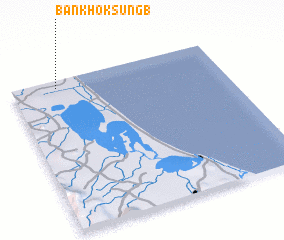 Places with similar names to Ban Khok Sung (1), Thailand ::
// Ban Khok Sung (1) (TH)
Disclaimer :: Information on this page comes without warranty of any kind |
||
|
Where is Ban Khok Sung (1)? Elevation and coordinates ::
Latitude (lat): 7°57'0"N Longitude (lon): 100°13'0"E
Elevation (approx.): 7m (map arrows pan, magnifying glasses zoom) |
||
|
Visiting Ban Khok Sung (1)? Hotel/Accommodation ::
Book a hotel in Ban Khok Sung (1) Travel Guide ::
Buy a travel guide for Thailand rental cars ::
car rental offers GPS waypoint ::
download a GPX waypoint (PoI) of Ban Khok Sung (1) for your GPS receiver
|
||