|
search place name
|
||
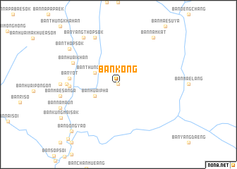
Ban Kong (Thailand)Ban Kong is a town in Thailand. An overview map of the region around Ban Kong is displayed below.
regional and 3d topo map of Ban Kong, Thailand ::
Ban Kong airports ::
The nearest airport is MOG - Mong Hsat, located 175.5 km north east of Ban Kong.
Other airports nearby include HEH - Heho (194.9 km north west), LPT - Lampang (201.4 km south east), THL - Tachilek Tachileik (230.6 km north east), KET - Kengtung (266.0 km north east), Nearby towns ::
Ban Mae Suya (0.0km north) //
Ban Huai Ma (4.0km south west) //
Ban Huai Pha (4.0km south west) //
Ban Thung Masan (4.0km north west) //
Ban Yot (7.3km west) //
Ban Mok Champae (7.3km west) //
Ban Huai Khan (7.6km north west) //
Ban Klang (7.7km west) //
Ban Na Pla Chat (8.2km north west) //
Ban Nam Pla Chat (8.2km north west) //
Ban Yang Thop Sok (9.1km north west) //
Ban Nam Kat (9.1km north east) //
Ban Thop Sok (9.2km north west) //
Ban Dong Yao (10.2km south west) //
Ban Pang Mu (11.5km south west) //
[all distances 'as the bird flies' and approximate]  Places with similar names to Ban Kong, Thailand ::
// Ban Kang (LA)
// Banakang (PH)
// Bangong (PH)
// Binguang (PH)
// Bincong (PH)
// Benking (AT)
// Ban A Kiang (TH)
// Ban Ao Kung (TH)
// Ban Kaeng (TH)
// Ban Kaeng (TH)
Disclaimer :: Information on this page comes without warranty of any kind |
||
|
Where is Ban Kong? Elevation and coordinates ::
Latitude (lat): 19°26'0"N Longitude (lon): 98°2'0"E
Elevation (approx.): 593m (map arrows pan, magnifying glasses zoom) |
||
|
Visiting Ban Kong? Hotel/Accommodation ::
Book a hotel in Ban Kong Travel Guide ::
Buy a travel guide for Thailand rental cars ::
car rental offers GPS waypoint ::
download a GPX waypoint (PoI) of Ban Kong for your GPS receiver
|
||