|
search place name
|
||
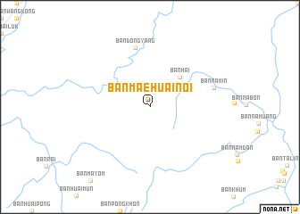
Ban Mae Huai Noi (Uttaradit, Thailand)Ban Mae Huai Noi is a town in the Uttaradit region of Thailand. An overview map of the region around Ban Mae Huai Noi is displayed below.
regional and 3d topo map of Ban Mae Huai Noi, Thailand ::
Ban Mae Huai Noi airports ::
The nearest airport is LOE - Loei, located 87.6 km south east of Ban Mae Huai Noi.
Other airports nearby include PRH - Phrae (95.5 km west), PHS - Phitsanulok (141.8 km south west), VTE - Vientiane Wattay Intl (164.6 km east), LPT - Lampang (166.8 km west), Nearby towns ::
Ban Nongpachit (3.9km north east) //
Ban Hai (5.1km north east) //
Ban Dong Yang (7.6km north) //
Ban Nam-In (8.0km east) //
[all distances 'as the bird flies' and approximate] 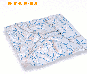 Places with similar names to Ban Mae Huai Noi, Thailand ::
// Ban Mae Hae Noi (TH)
// Ban Mae Han (TH)
// Ban Mae Hia Nai (TH)
// Ban Mae Hin (TH)
// Ban Mae Hoi Nai (TH)
// Ban Nam Hin (TH)
// Ban Namhan (LA)
// Ban Namhon (LA)
// Ban Namhoun (LA)
// Bunmahon (IE)
Disclaimer :: Information on this page comes without warranty of any kind |
||
|
Where is Ban Mae Huai Noi? Elevation and coordinates ::
Latitude (lat): 17°51'0"N Longitude (lon): 101°1'0"E
Elevation (approx.): 640m (map arrows pan, magnifying glasses zoom) |
||
|
Visiting Ban Mae Huai Noi? Hotel/Accommodation ::
Book a hotel in Ban Mae Huai Noi Travel Guide ::
Buy a travel guide for Thailand rental cars ::
car rental offers GPS waypoint ::
download a GPX waypoint (PoI) of Ban Mae Huai Noi for your GPS receiver
|
||