|
search place name
|
||
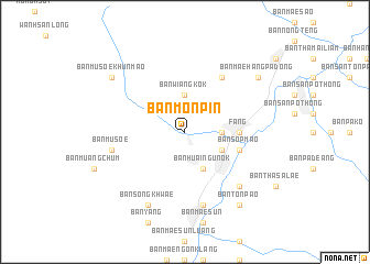
Ban Mon Pin (Chiang Mai, Thailand)Ban Mon Pin is a town in the Chiang Mai region of Thailand. An overview map of the region around Ban Mon Pin is displayed below.
regional and 3d topo map of Ban Mon Pin, Thailand ::
Ban Mon Pin airports ::
The nearest airport is MOG - Mong Hsat, located 67.1 km north of Ban Mon Pin.
Other airports nearby include THL - Tachilek Tachileik (102.0 km north east), KET - Kengtung (160.9 km north), LPT - Lampang (185.6 km south), PRH - Phrae (223.7 km south east), Nearby towns ::
Ban Wiang Kok (3.7km north) //
Ban Mae Mao (3.5km east) //
Ban Huai Ngu (3.9km south east) //
Amphoe Fang (4.1km south east) //
Ban Huai Ngu Nok (4.1km south east) //
Fang (5.2km east) //
Ban Sop Mao (5.5km east) //
Ban Huai Bon (6.6km north east) //
Ban Nong Yao (7.6km south) //
Ban Musoe (7.2km west) //
Ban Hua Dong (7.6km south east) //
Ban Mae Sun Noi (8.2km south west) //
Ban Song Khwae (8.2km south west) //
Ban Mae Hang Pa Dong (8.9km north east) //
Ban Musoe Khun Mao (8.9km north west) //
Ban San Pa Bong (9.1km south east) //
Ban Ton Pao (9.1km south east) //
[all distances 'as the bird flies' and approximate]  Places with similar names to Ban Mon Pin, Thailand :: Disclaimer :: Information on this page comes without warranty of any kind |
||
|
Where is Ban Mon Pin? Elevation and coordinates ::
Latitude (lat): 19°55'0"N Longitude (lon): 99°10'0"E
Elevation (approx.): 483m (map arrows pan, magnifying glasses zoom) |
||
|
Visiting Ban Mon Pin? Hotel/Accommodation ::
Book a hotel in Ban Mon Pin Travel Guide ::
Buy a travel guide for Thailand rental cars ::
car rental offers GPS waypoint ::
download a GPX waypoint (PoI) of Ban Mon Pin for your GPS receiver
|
||