|
search place name
|
||
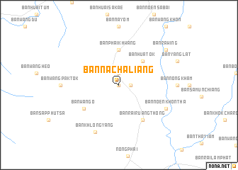
Ban Na Chaliang (Phetchabun, Thailand)Ban Na Chaliang is a town in the Phetchabun region of Thailand. An overview map of the region around Ban Na Chaliang is displayed below.
regional and 3d topo map of Ban Na Chaliang, Thailand ::
Ban Na Chaliang airports ::
The nearest airport is PHS - Phitsanulok, located 113.0 km north west of Ban Na Chaliang.
Other airports nearby include LOE - Loei (166.3 km north east), NAK - Nakhon Ratchasima Khorat (168.3 km south east), UTH - Udon Thani (234.8 km north east), VTE - Vientiane Wattay Intl (265.3 km north east), Nearby towns ::
Ban Long Kha (0.0km north) //
Ban Huai Nam Bo (1.9km north) //
Ban Takrut Chik (1.8km east) //
Ban Hua Tok (5.1km north east) //
Ban Phai Khwang (5.6km north) //
Ban Wang O (6.5km south west) //
Ban Rai Ruang Thong (6.6km south east) //
Ban Khlong Yang (8.2km south west) //
Ban Noen Khontha (8.0km south east) //
Ban Rawing (9.0km north east) //
[all distances 'as the bird flies' and approximate]  Places with similar names to Ban Na Chaliang, Thailand ::
// Ban Chalaeng (TH)
// Ban Chalong (TH)
// Ban Chalung (TH)
// Ban Na Chalong (TH)
// Ban Chalèng (LA)
// Ban Chaling (LA)
// Ban Nachaling (LA)
// Bản Cho Lung (VN)
// Banshiling (CN)
Disclaimer :: Information on this page comes without warranty of any kind |
||
|
Where is Ban Na Chaliang? Elevation and coordinates ::
Latitude (lat): 16°5'0"N Longitude (lon): 101°3'0"E
Elevation (approx.): 117m (map arrows pan, magnifying glasses zoom) |
||
|
Visiting Ban Na Chaliang? Hotel/Accommodation ::
Book a hotel in Ban Na Chaliang Travel Guide ::
Buy a travel guide for Thailand rental cars ::
car rental offers GPS waypoint ::
download a GPX waypoint (PoI) of Ban Na Chaliang for your GPS receiver
|
||