|
search place name
|
||
Ban Na Phra (Lop Buri, Thailand)Ban Na Phra is a town in the Lop Buri region of Thailand. An overview map of the region around Ban Na Phra is displayed below.
regional and 3d topo map of Ban Na Phra, Thailand ::

Ban Na Phra airports ::
The nearest airport is BKK - Bangkok Intl, located 134.1 km south of Ban Na Phra.
Other airports nearby include NAK - Nakhon Ratchasima Khorat (144.3 km east), PHS - Phitsanulok (191.2 km north), Nearby towns ::
Ban Nong Samrong (2.6km south east) //
Ban Wang Hua Waen (2.6km south west) //
Ban Huai Yai (4.0km north east) //
Ban Tha Muang (5.7km west) //
Khok Samrong (6.5km south west) //
Ban Nong Khoi (7.0km north west) //
Ban Saphan Khong (7.2km east) //
Ban Noi (8.0km south) //
Ban Tha Chanuan (8.1km south west) //
Ban Thalung Lek (9.1km south west) //
Ban Hua Sa (9.1km south west) //
Ban Nong Bua Thing (9.1km south west) //
[all distances 'as the bird flies' and approximate] 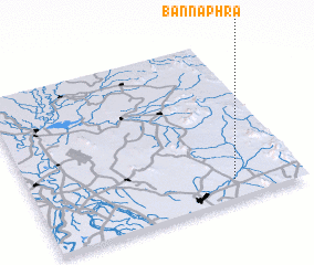 Places with similar names to Ban Na Phra, Thailand ::
// Bou Anfer (MA)
// Ban Ao Phra (TH)
// Ban Fao Rai (TH)
// Ban Fao Rai (TH)
// Ban Fao Rai (TH)
// Ban Nai Phru (TH)
// Ban Na Phrai (TH)
// Ban Na Phrai (TH)
// Ban Na Phrao (TH)
// Ban Na Phru (TH)
Disclaimer :: Information on this page comes without warranty of any kind |
||
|
Where is Ban Na Phra? Elevation and coordinates ::
Latitude (lat): 15°7'0"N Longitude (lon): 100°45'0"E
Elevation (approx.): 30m (map arrows pan, magnifying glasses zoom) |
||
|
Visiting Ban Na Phra? Hotel/Accommodation ::
Book a hotel in Ban Na Phra Travel Guide ::
Buy a travel guide for Thailand rental cars ::
car rental offers GPS waypoint ::
download a GPX waypoint (PoI) of Ban Na Phra for your GPS receiver
|
||