|
search place name
|
||
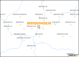
Ban Noen Phoem (1) (Phitsanulok, Thailand)Ban Noen Phoem (1) is a town in the Phitsanulok region of Thailand. An overview map of the region around Ban Noen Phoem (1) is displayed below.
regional and 3d topo map of Ban Noen Phoem (1), Thailand ::
Ban Noen Phoem (1) airports ::
The nearest airport is PHS - Phitsanulok, located 72.7 km south west of Ban Noen Phoem (1).
Other airports nearby include LOE - Loei (97.7 km east), PRH - Phrae (134.8 km north west), LPT - Lampang (192.9 km north west), VTE - Vientiane Wattay Intl (204.3 km north east), Nearby towns ::
Ban Nam Phai (1.9km north) //
Ban Huai Na (1) (1.8km east) //
Nakhon Thai (3.5km west) //
Ban Hua Na (3.7km south) //
Ban Non Tum (4.1km north east) //
Ban Om Sing (4.0km north east) //
Ban Na Bua (5.6km north) //
Ban Nong Kradat (7.1km west) //
Ban Na Yao (7.1km west) //
Ban Tha Hin Lat (7.3km east) //
Ban Nam Phrik (9.1km north east) //
Ban Nong Krathao (9.0km south west) //
[all distances 'as the bird flies' and approximate] 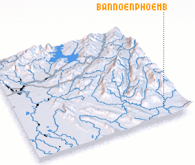 Places with similar names to Ban Noen Phoem (1), Thailand ::
// Ban Noen Phoem (TH)
// Ban Noen Phoem (TH)
Disclaimer :: Information on this page comes without warranty of any kind |
||
|
Where is Ban Noen Phoem (1)? Elevation and coordinates ::
Latitude (lat): 17°7'0"N Longitude (lon): 100°52'0"E
Elevation (approx.): 211m (map arrows pan, magnifying glasses zoom) |
||
|
Visiting Ban Noen Phoem (1)? Hotel/Accommodation ::
Book a hotel in Ban Noen Phoem (1) Travel Guide ::
Buy a travel guide for Thailand rental cars ::
car rental offers GPS waypoint ::
download a GPX waypoint (PoI) of Ban Noen Phoem (1) for your GPS receiver
|
||