|
search place name
|
||
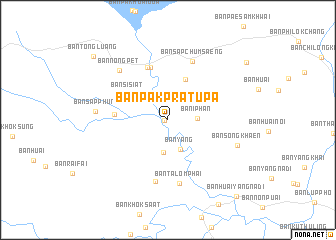
Ban Pak Pratu Pa (Chaiyaphum, Thailand)Ban Pak Pratu Pa is a town in the Chaiyaphum region of Thailand. An overview map of the region around Ban Pak Pratu Pa is displayed below.
regional and 3d topo map of Ban Pak Pratu Pa, Thailand ::
Ban Pak Pratu Pa airports ::
The nearest airport is NAK - Nakhon Ratchasima Khorat, located 110.8 km south of Ban Pak Pratu Pa.
Other airports nearby include LOE - Loei (173.1 km north), PHS - Phitsanulok (184.1 km north west), UTH - Udon Thani (202.3 km north east), BKK - Bangkok Intl (248.1 km south west), Nearby towns ::
Ban Nong O (0.4km west) //
Ban I Phan (3.2km east) //
Ban Yang (3.6km south) //
Ban Huai Chiang (3.7km south) //
Ban Huai Cham Chong (4.9km north east) //
Ban Si Siat (5.0km north west) //
Ban Huai Yae (5.8km west) //
Ban Huai Nam Dam (6.1km north) //
Ban Nari (6.3km north) //
Ban Huai Rai (7.0km south) //
Ban Sap Chum Saeng (7.0km north) //
Ban Talom Phai (7.2km south) //
Ban Nong Pet (7.6km north west) //
Ban Sap Phun (7.8km west) //
Ban Song Khaen (8.0km east) //
Ban Tong Luang (10.7km north west) //
Ban Sam Khwai Noi (10.6km north east) //
Ban Huai Yang Na Di (11.2km south east) //
[all distances 'as the bird flies' and approximate]  Places with similar names to Ban Pak Pratu Pa, Thailand :: Disclaimer :: Information on this page comes without warranty of any kind |
||
|
Where is Ban Pak Pratu Pa? Elevation and coordinates ::
Latitude (lat): 15°52'29"N Longitude (lon): 101°43'21"E
Elevation (approx.): 213m (map arrows pan, magnifying glasses zoom) |
||
|
Visiting Ban Pak Pratu Pa? Hotel/Accommodation ::
Book a hotel in Ban Pak Pratu Pa Travel Guide ::
Buy a travel guide for Thailand rental cars ::
car rental offers GPS waypoint ::
download a GPX waypoint (PoI) of Ban Pak Pratu Pa for your GPS receiver
|
||