|
search place name
|
||
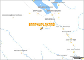
Ban Phu Pla Kang (Kanchanaburi, Thailand)Ban Phu Pla Kang is a town in the Kanchanaburi region of Thailand. An overview map of the region around Ban Phu Pla Kang is displayed below.
regional and 3d topo map of Ban Phu Pla Kang, Thailand ::
Ban Phu Pla Kang airports ::
The nearest airport is BKK - Bangkok Intl, located 169.2 km east of Ban Phu Pla Kang.
Other airports nearby include HHQ - Prachuap Khiri Khan Hua Hin (209.2 km south east), MGZ - Myeik (215.8 km south), UTP - Rayong U Taphao Intl (275.7 km south east), Nearby towns ::
Ban Mong Lai Bon (2.6km north east) //
Ban Mong Lai (5.2km north east) //
Ban Plai Huai Kaeng Riang (7.5km north) //
Ban Phu Sok (7.6km north) //
Ban Tab Tao (8.1km north east) //
Ban Omduan (9.2km north west) //
Ban Phu Taeng Mo (9.1km north east) //
Ban Sam Khot Lang (9.2km north east) //
Ban Sam Khot Bon (10.3km north east) //
[all distances 'as the bird flies' and approximate] 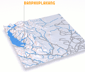 Places with similar names to Ban Phu Pla Kang, Thailand :: Disclaimer :: Information on this page comes without warranty of any kind |
||
|
Where is Ban Phu Pla Kang? Elevation and coordinates ::
Latitude (lat): 14°20'0"N Longitude (lon): 99°6'0"E
Elevation (approx.): 699m (map arrows pan, magnifying glasses zoom) |
||
|
Visiting Ban Phu Pla Kang? Hotel/Accommodation ::
Book a hotel in Ban Phu Pla Kang Travel Guide ::
Buy a travel guide for Thailand rental cars ::
car rental offers GPS waypoint ::
download a GPX waypoint (PoI) of Ban Phu Pla Kang for your GPS receiver
|
||