|
search place name
|
||
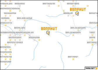
Ban Phut (Thailand)Ban Phut is a town in Thailand. An overview map of the region around Ban Phut is displayed below.
regional and 3d topo map of Ban Phut, Thailand ::
Ban Phut airports ::
The nearest airport is TST - Trang, located 37.8 km north west of Ban Phut.
Other airports nearby include HDY - Songkhla Hat Yai Intl (69.0 km south east), LGK - Pulau Langkawi Intl (110.8 km south), NST - Nakhon Si Thammarat Cha Ian (127.8 km north), AOR - Alor Setar Sultan Abdul Halim (136.3 km south east), Nearby towns ::
Ban Khlong Wa Rang (0.0km north) //
Ban Daen Mi (4.1km south west) //
Ban Mai Dam (1) (5.8km west) //
Ban Sam Yaek Lam Khlaeng (7.4km west) //
Ban Na Len (10.4km north east) //
[all distances 'as the bird flies' and approximate]  Places with similar names to Ban Phut, Thailand ::
// Beni Fouda (MA)
// Benefit (US)
// Benfeita (PT)
// Ban Ao Fat (TH)
// Ban A Phat (TH)
// Ban Aphut (TH)
// Ban Fit (TH)
// Ban Na Phaet (TH)
// Ban Pha Di (TH)
// Ban Pha Dui (TH)
Disclaimer :: Information on this page comes without warranty of any kind |
||
|
Where is Ban Phut? Elevation and coordinates ::
Latitude (lat): 7°19'0"N Longitude (lon): 99°54'0"E
Elevation (approx.): 897m (map arrows pan, magnifying glasses zoom) |
||
|
Visiting Ban Phut? Hotel/Accommodation ::
Book a hotel in Ban Phut Travel Guide ::
Buy a travel guide for Thailand rental cars ::
car rental offers GPS waypoint ::
download a GPX waypoint (PoI) of Ban Phut for your GPS receiver
|
||