|
search place name
|
||
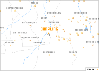
Ban Pling (Buriram, Thailand)Ban Pling is a town in the Buriram region of Thailand. An overview map of the region around Ban Pling is displayed below.
regional and 3d topo map of Ban Pling, Thailand ::
Ban Pling airports ::
The nearest airport is REP - Siem-reap Siem Reap, located 129.3 km south east of Ban Pling.
Other airports nearby include NAK - Nakhon Ratchasima Khorat (136.2 km north west), Nearby towns ::
Ban Ta Miang (2.6km east) //
Ban Phun Suk (3.4km east) //
Ban Nong Chup (3.9km south east) //
Ban Sa Kaeo (4.2km north east) //
Ban Sai Taku (5.2km south west) //
Ban Nong Khaen (5.4km north east) //
Ban La-O (5.4km north east) //
Ban Phanom Din Mai (5.5km east) //
Ban Wa (5.8km north) //
Ban Wari (5.7km east) //
Ban Ta Miang (7.4km south) //
Ban Hua Ang (7.3km east) //
Ban Lahok Tabaeng (7.4km west) //
Ban Khok Klang (7.6km north) //
Ban Run (7.4km east) //
Ban Don Nam Tan (7.6km east) //
Ban Phanom Dong Rak (7.7km east) //
Ban Tha Sawang (7.9km east) //
Ban Thanon Khat (8.1km north west) //
Ban Nong Ta Loep (8.2km east) //
Ban Chik Daek (9.5km north east) //
Ban Sai Kulap (9.7km north east) //
Ban Khok Marum (10.8km north east) //
[all distances 'as the bird flies' and approximate]  Places with similar names to Ban Pling, Thailand ::
// Ban Na Plang (TH)
// Ban Pae Luang (TH)
// Ban Plaeng (TH)
// Ban Pleng (TH)
// Ban Pling (TH)
// Buna Palang (IN)
// Ban Paléng (LA)
// Ban Paliang (LA)
// Ban Palong (LA)
// Ban Palông (LA)
Disclaimer :: Information on this page comes without warranty of any kind |
||
|
Where is Ban Pling? Elevation and coordinates ::
Latitude (lat): 14°26'0"N Longitude (lon): 103°14'0"E
Elevation (approx.): 179m (map arrows pan, magnifying glasses zoom) |
||
|
Visiting Ban Pling? Hotel/Accommodation ::
Book a hotel in Ban Pling Travel Guide ::
Buy a travel guide for Thailand rental cars ::
car rental offers GPS waypoint ::
download a GPX waypoint (PoI) of Ban Pling for your GPS receiver
|
||