|
search place name
|
||
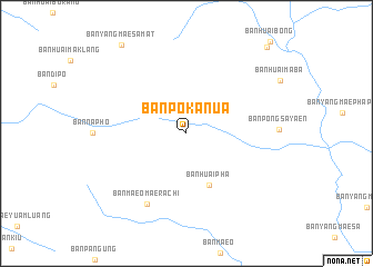
Ban Po Ka Nua (Chiang Mai, Thailand)Ban Po Ka Nua is a town in the Chiang Mai region of Thailand. An overview map of the region around Ban Po Ka Nua is displayed below.
regional and 3d topo map of Ban Po Ka Nua, Thailand ::
Ban Po Ka Nua airports ::
The nearest airport is LPT - Lampang, located 154.7 km south east of Ban Po Ka Nua.
Other airports nearby include MOG - Mong Hsat (209.6 km north east), PRH - Phrae (224.5 km east), HEH - Heho (251.3 km north west), THL - Tachilek Tachileik (252.0 km north east), Nearby towns ::
Ban Huai Pha (5.6km south) //
Ban Maeo Mae Rachi (8.0km south west) //
Ban Yang Mae Samat (10.8km north west) //
Ban Huai Tong (11.6km north east) //
[all distances 'as the bird flies' and approximate] 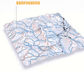 Places with similar names to Ban Po Ka Nua, Thailand ::
// Ban Pok Nai (TH)
// Ban Pu Kon (TH)
// Ban Paka Noy (LA)
// Ban Pak-En (LA)
// Ban Pakkôn (LA)
// Ban Pakon (LA)
// Ban Pakouan (LA)
// Ban Pakouay Nua (LA)
// Ban Pak Uon (LA)
// Bản Pai Quanh (VN)
Disclaimer :: Information on this page comes without warranty of any kind |
||
|
Where is Ban Po Ka Nua? Elevation and coordinates ::
Latitude (lat): 18°54'32"N Longitude (lon): 98°12'1"E
Elevation (approx.): 1394m (map arrows pan, magnifying glasses zoom) |
||
|
Visiting Ban Po Ka Nua? Hotel/Accommodation ::
Book a hotel in Ban Po Ka Nua Travel Guide ::
Buy a travel guide for Thailand rental cars ::
car rental offers GPS waypoint ::
download a GPX waypoint (PoI) of Ban Po Ka Nua for your GPS receiver
|
||