|
search place name
|
||
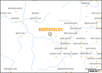
Ban Rong Lek (Nakhon Si Thammarat, Thailand)Ban Rong Lek is a town in the Nakhon Si Thammarat region of Thailand. An overview map of the region around Ban Rong Lek is displayed below.
regional and 3d topo map of Ban Rong Lek, Thailand ::
Ban Rong Lek airports ::
The nearest airport is NST - Nakhon Si Thammarat Cha Ian, located 36.8 km south east of Ban Rong Lek.
Other airports nearby include TST - Trang (136.2 km south), HKT - Phuket Intl (172.1 km south west), HDY - Songkhla Hat Yai Intl (211.3 km south), PAN - Pattani (265.3 km south east), Nearby towns ::
Ban Suan Klang (1.8km east) //
Ban Kha Som (4.1km south east) //
Ban Huai Yot (5.2km south east) //
Ban Lum Not (5.8km east) //
Ban Wang Lao (6.7km south east) //
Ban Na Non (6.6km south east) //
Ban Chum Long (7.3km east) //
Ban Na Tham (7.6km south) //
Ban Phi Tam (7.8km north west) //
Ban Don Khrai (8.2km north east) //
Ban Nop (9.2km north west) //
Ban Pa Phet (9.2km south east) //
Ban Hua Thung (2) (10.4km south east) //
[all distances 'as the bird flies' and approximate]  Places with similar names to Ban Rong Lek, Thailand ::
// Ban Rang Luak (TH)
Disclaimer :: Information on this page comes without warranty of any kind |
||
|
Where is Ban Rong Lek? Elevation and coordinates ::
Latitude (lat): 8°44'0"N Longitude (lon): 99°45'0"E
Elevation (approx.): 34m (map arrows pan, magnifying glasses zoom) |
||
|
Visiting Ban Rong Lek? Hotel/Accommodation ::
Book a hotel in Ban Rong Lek Travel Guide ::
Buy a travel guide for Thailand rental cars ::
car rental offers GPS waypoint ::
download a GPX waypoint (PoI) of Ban Rong Lek for your GPS receiver
|
||