|
search place name
|
||
Ban Suan Som (Nakhon Pathom, Thailand)Ban Suan Som is a town in the Nakhon Pathom region of Thailand. An overview map of the region around Ban Suan Som is displayed below.
regional and 3d topo map of Ban Suan Som, Thailand ::

Ban Suan Som airports ::
The nearest airport is BKK - Bangkok Intl, located 44.1 km east of Ban Suan Som.
Other airports nearby include HHQ - Prachuap Khiri Khan Hua Hin (140.6 km south), UTP - Rayong U Taphao Intl (159.2 km south east), NAK - Nakhon Ratchasima Khorat (233.6 km north east), MGZ - Myeik (234.1 km south west), Nearby towns ::
Ban Phai Khat (0.0km north) //
Ban Bang Phra (1.9km north) //
Ban Bang Kaeo Fa (1.8km east) //
Ban Don Chedi (2.6km south west) //
Ban Talat Huai Phlu (2.6km south east) //
Ban Bang Pla Duk (2.6km south east) //
Ban Phrong Khe (2.6km south west) //
Ban Bang Kraba (2.6km north east) //
Ban Khlong Laksa (3.7km north) //
Ban Si Maha Pho (4.0km south west) //
Ban Don Faek (4.1km south east) //
Ban Lan Laem (4.0km north west) //
Ban Bang Khamoi (4.1km north east) //
Ban Bang Rakam (5.6km north) //
Ban Khok Chang (5.7km west) //
Ban Thung Phai Ling (5.8km north) //
Ban Lan Tak Fa (6.6km south east) //
Ban Laem Bua (6.6km south west) //
Ban Nong Kaphi (6.5km north west) //
Ban Luang (6.5km north west) //
Ban Huai Krot (7.2km west) //
Ban Ngiu Rai (1) (7.6km south) //
Ban Lan Tak Fa (7.6km south) //
Ban Kluai (7.6km south) //
Ban Khok Khema (7.4km west) //
Ban Khlong Chek (2) (7.4km east) //
Ban Lam Phaya (7.6km north) //
Ban Thong Sai (7.7km south west) //
Ban Laem Cha-Ui (8.2km north east) //
[all distances 'as the bird flies' and approximate] 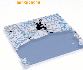 Places with similar names to Ban Suan Som, Thailand ::
// Ban Saen Samai (TH)
// Ban Suan Som (TH)
// Ban Sène Sum (LA)
// Ban Sènsam (LA)
// Ban Sènsam (LA)
// Ban Sèn som (LA)
Disclaimer :: Information on this page comes without warranty of any kind |
||
|
Where is Ban Suan Som? Elevation and coordinates ::
Latitude (lat): 13°53'0"N Longitude (lon): 100°12'0"E
Elevation (approx.): 6m (map arrows pan, magnifying glasses zoom) |
||
|
Visiting Ban Suan Som? Hotel/Accommodation ::
Book a hotel in Ban Suan Som Travel Guide ::
Buy a travel guide for Thailand rental cars ::
car rental offers GPS waypoint ::
download a GPX waypoint (PoI) of Ban Suan Som for your GPS receiver
|
||