|
search place name
|
||
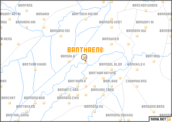
Ban Thaen (1) (Nakhon Ratchasima, Thailand)Ban Thaen (1) is a town in the Nakhon Ratchasima region of Thailand. An overview map of the region around Ban Thaen (1) is displayed below.
regional and 3d topo map of Ban Thaen (1), Thailand ::
Ban Thaen (1) airports ::
The nearest airport is NAK - Nakhon Ratchasima Khorat, located 79.2 km south west of Ban Thaen (1).
Other airports nearby include REP - Siem-reap Siem Reap (249.2 km south east), SNO - Sakon Nakhon (255.0 km north east), Nearby towns ::
Ban Makok (0.0km north) //
Ban Sala (3.6km west) //
Ban Samrong (3.7km south) //
Ban Khwao (3.7km south) //
Ban Tha Phayung (5.1km south east) //
Ban Chong Maeo (5.1km south east) //
Ban Non Sa Haeng (5.6km south) //
Ban Suan Mon (5.6km south) //
Ban Sakae (5.8km south) //
Ban Yai Pha (5.8km south) //
Ban Non Lalom (5.7km east) //
Ban Sukon (6.5km north east) //
Ban Nong Kham (7.4km south) //
Ban Pra Suk (7.6km south) //
Ban Dong Noi (7.7km north west) //
Ban La-wo (7.7km south east) //
Ban Dua (8.1km south east) //
Ban Khok Tong (8.2km south east) //
Ban Wat Chan (8.2km south west) //
Ban Nong Krot (9.1km north east) //
Ban Kluai (9.1km south west) //
[all distances 'as the bird flies' and approximate]  Places with similar names to Ban Thaen (1), Thailand ::
// Ban Nai Thon (1) (TH)
// Ban Thon (1) (TH)
// Ban Thènbè (LA)
// Ban Thôn Noy (1) (LA)
// Ban Thoun (1) (LA)
// Bản Than (1) (VN)
// Bình Thanh (1) (VN)
// Bình Thanh (1) (VN)
// Bình Thành (1) (VN)
Disclaimer :: Information on this page comes without warranty of any kind |
||
|
Where is Ban Thaen (1)? Elevation and coordinates ::
Latitude (lat): 15°22'0"N Longitude (lon): 102°40'0"E
Elevation (approx.): 147m (map arrows pan, magnifying glasses zoom) |
||
|
Visiting Ban Thaen (1)? Hotel/Accommodation ::
Book a hotel in Ban Thaen (1) Travel Guide ::
Buy a travel guide for Thailand rental cars ::
car rental offers GPS waypoint ::
download a GPX waypoint (PoI) of Ban Thaen (1) for your GPS receiver
|
||