|
search place name
|
||
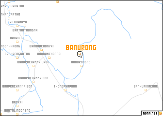
Ban Urong (Kanchanaburi, Thailand)Ban Urong is a town in the Kanchanaburi region of Thailand. An overview map of the region around Ban Urong is displayed below.
regional and 3d topo map of Ban Urong, Thailand ::
Ban Urong airports ::
The nearest airport is BKK - Bangkok Intl, located 231.2 km south east of Ban Urong.
Other airports nearby include PHS - Phitsanulok (279.3 km north east), Nearby towns ::
Ban Huai Haeng (1.9km north) //
Ban Urong Noi (1.9km south) //
Ban Nam Chon Noi (7.2km west) //
Ban Thong Pha Phum (8.2km south west) //
Thong Pha Phum (8.2km south west) //
[all distances 'as the bird flies' and approximate] 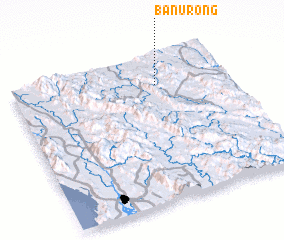 Places with similar names to Ban Urong, Thailand ::
// Ban Arang (TH)
// Ban I Raeng (TH)
// Ban Na Rang (TH)
// Ban Na Riang (TH)
// Ban Na Riang (TH)
// Ban Na Riang (TH)
// Ban Na Riang (TH)
// Ban Na Ruang (TH)
// Ban Na Ruang (TH)
// Ban Ranuk (TH)
Disclaimer :: Information on this page comes without warranty of any kind |
||
|
Where is Ban Urong? Elevation and coordinates ::
Latitude (lat): 14°48'0"N Longitude (lon): 98°40'0"E
Elevation (approx.): 149m (map arrows pan, magnifying glasses zoom) |
||
|
Visiting Ban Urong? Hotel/Accommodation ::
Book a hotel in Ban Urong Travel Guide ::
Buy a travel guide for Thailand rental cars ::
car rental offers GPS waypoint ::
download a GPX waypoint (PoI) of Ban Urong for your GPS receiver
|
||