|
search place name
|
||
Kaset Wisai (Roi Et, Thailand)Kaset Wisai is a town in the Roi Et region of Thailand. An overview map of the region around Kaset Wisai is displayed below.
regional and 3d topo map of Kaset Wisai, Thailand ::

Kaset Wisai airports ::
The nearest airport is ZVK - Savannakhet, located 160.9 km north east of Kaset Wisai.
Other airports nearby include NAK - Nakhon Ratchasima Khorat (180.0 km south west), SNO - Sakon Nakhon (180.3 km north), UTH - Udon Thani (210.1 km north west), LOE - Loei (280.5 km north west), Nearby towns ::
Ban Nong Waeng (1.9km south) //
Ban Nong Waeng (2.0km north west) //
Ban Hua Dong Kamphaeng (4.6km south east) //
Ban Nong Sao (5.8km north) //
Ban Muang Bua (5.8km south) //
Ban Um Mao (6.6km north west) //
Ban Nam Om (7.4km west) //
Ban Phon Ngoen (7.7km south west) //
Ban Song Khaen (7.9km east) //
Ban Khilek Sai (8.2km east) //
Ban Khwao Yai (8.9km north west) //
Ban Pham (9.0km north west) //
Ban Nong Ben (9.0km south east) //
Ban Non Chan (9.3km south west) //
[all distances 'as the bird flies' and approximate] 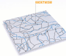
Disclaimer :: Information on this page comes without warranty of any kind |
||
|
Where is Kaset Wisai? Elevation and coordinates ::
Latitude (lat): 15°39'0"N Longitude (lon): 103°35'0"E
Elevation (approx.): 136m (map arrows pan, magnifying glasses zoom) |
||
|
Visiting Kaset Wisai? Hotel/Accommodation ::
Book a hotel in Kaset Wisai Travel Guide ::
Buy a travel guide for Thailand rental cars ::
car rental offers GPS waypoint ::
download a GPX waypoint (PoI) of Kaset Wisai for your GPS receiver
|
||