|
search place name
|
||
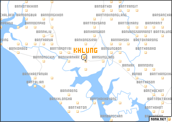
Khlung (Chanthaburi, Thailand)Khlung is a town in the Chanthaburi region of Thailand. An overview map of the region around Khlung is displayed below.
regional and 3d topo map of Khlung, Thailand ::
Khlung airports ::
The nearest airport is UTP - Rayong U Taphao Intl, located 135.9 km west of Khlung.
Other airports nearby include REP - Siem-reap Siem Reap (201.7 km north east), BKK - Bangkok Intl (239.3 km north west), Nearby towns ::
Ban Wan Yao Lang (0.0km north) //
Ban Khlong Khlung (1) (0.0km north) //
Ban Wan Yao Bon (1.9km north) //
Ban Khlong Takhian (1.9km south) //
Ban Kwian Hak (3.6km west) //
Ban Kongsi Rai (3.7km north) //
Ban Sung Klang (3.6km east) //
Ban Sung Lang (3.6km east) //
Ban Khan Rut (4.1km north west) //
Ban Tapon Yai (5.7km west) //
Ban Sung Bon (5.7km east) //
Ban I Mang Bon (5.8km north) //
Ban I Mang Lang (6.6km north east) //
Ban Nong Lahan (7.2km east) //
Ban Chang Kham (7.5km east) //
Ban Trok Sano (7.6km north) //
Ban Khao Nong Kon (8.1km south west) //
Ban Tapon Noi (8.1km north west) //
Ban I Raeng (8.2km south west) //
Ban Nam Sok (8.1km north east) //
Ban Lahan Nai (8.1km north east) //
Ban Pa Khan (9.1km north west) //
Ban Chak Yai (10.4km north west) //
[all distances 'as the bird flies' and approximate] 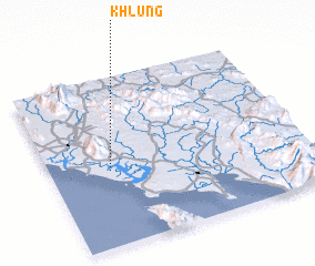 Places with similar names to Khlung, Thailand ::
Disclaimer :: Information on this page comes without warranty of any kind |
||
|
Where is Khlung? Elevation and coordinates ::
Latitude (lat): 12°27'0"N Longitude (lon): 102°14'0"E
Elevation (approx.): 10m (map arrows pan, magnifying glasses zoom) |
||
|
Visiting Khlung? Hotel/Accommodation ::
Book a hotel in Khlung Travel Guide ::
Buy a travel guide for Thailand rental cars ::
car rental offers GPS waypoint ::
download a GPX waypoint (PoI) of Khlung for your GPS receiver
|
||