|
search place name
|
||
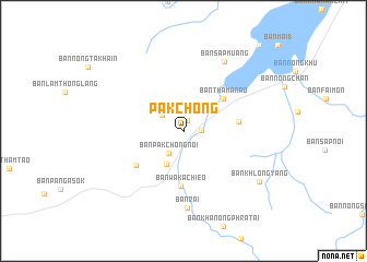
Pak Chong (Nakhon Ratchasima, Thailand)Pak Chong is a town in the Nakhon Ratchasima region of Thailand. An overview map of the region around Pak Chong is displayed below.
regional and 3d topo map of Pak Chong, Thailand ::
Pak Chong airports ::
The nearest airport is NAK - Nakhon Ratchasima Khorat, located 76.0 km east of Pak Chong.
Other airports nearby include BKK - Bangkok Intl (123.4 km south west), Nearby towns ::
Ban Sao Thong (1.2km north) //
Ban Nong Sarai (1) (1.8km east) //
Ban Chong Khae (2.6km north east) //
Ban Pak Chong Noi (2.7km south west) //
Ban Nong Ka Cha (2.7km north west) //
Ban Pang Kae (3.7km south west) //
Ban Tha Manao (5.1km north east) //
Ban Wa Kachieo (5.7km south) //
Ban Thung Sawang (5.5km east) //
Ban Sathani Bandai Ma (5.9km south west) //
Ban Rai (7.9km south) //
Ban Sap Muang (8.1km north east) //
Ban Khlong Yang (9.1km south east) //
Ban Chan Thuk (11.6km north east) //
[all distances 'as the bird flies' and approximate]  Places with similar names to Pak Chong, Thailand ::
// Paukchaung (MM)
// Paukchaung (MM)
// Paukchaung (MM)
// Paukchaung (MM)
// Paekchung (KP)
// Pukch'ang (KR)
// Pukch'ang (KR)
// Pukch'ang (KP)
// Pukshen'ga (RU)
// Hpukchang (MM)
Disclaimer :: Information on this page comes without warranty of any kind |
||
|
Where is Pak Chong? Elevation and coordinates ::
Latitude (lat): 14°42'15"N Longitude (lon): 101°24'47"E
Elevation (approx.): 311m (map arrows pan, magnifying glasses zoom) |
||
|
Visiting Pak Chong? Hotel/Accommodation ::
Book a hotel in Pak Chong Travel Guide ::
Buy a travel guide for Thailand rental cars ::
car rental offers GPS waypoint ::
download a GPX waypoint (PoI) of Pak Chong for your GPS receiver
|
||