|
search place name
|
||
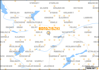
Bondziszki (Poland)Bondziszki is a town in Poland. An overview map of the region around Bondziszki is displayed below.
regional and 3d topo map of Bondziszki, Poland ::
Nearby towns ::
Palemonie (1.9km south) //
Lizdejki (2.1km south east) //
Jodjeziory (2.1km south west) //
Poplin (2.2km west) //
Ługiele (2.2km west) //
Rowele (3.9km north) //
Postawale (2.8km south east) //
Kleszczówek (3.9km south) //
Marianka (4.3km north west) //
Smolniki (4.3km south west) //
Jegliniszki (3.2km west) //
Kamionka (5.6km north) //
Sidory (5.7km south) //
Rogożajny Wielkie (3.7km north west) //
Soliny (3.7km north west) //
Rogożajny Małe (4.9km north west) //
Potopy (4.9km north east) //
Uzdziejek (6.0km south) //
Rutka Tartak (4.3km east) //
Baranowo (4.3km east) //
Gulbieniszki (7.4km south) //
Wysokie (7.5km north) //
Dzierwiany (4.7km south west) //
Podsumowo (6.4km south east) //
Łopuchowo (6.4km south west) //
Jałowo (6.4km south east) //
Hultajewo (6.4km south east) //
Olszanka (6.4km north east) //
Maszutkinie (7.7km north) //
[all distances 'as the bird flies' and approximate]  Places with similar names to Bondziszki, Poland :: Disclaimer :: Information on this page comes without warranty of any kind |
||
|
Where is Bondziszki? Elevation and coordinates ::
Latitude (lat): 54°19'0"N Longitude (lon): 22°55'0"E
Elevation (approx.): 229m (map arrows pan, magnifying glasses zoom) |
||
|
Visiting Bondziszki? Hotel/Accommodation ::
Book a hotel in Bondziszki Travel Guide ::
Buy a travel guide for Poland rental cars ::
car rental offers GPS waypoint ::
download a GPX waypoint (PoI) of Bondziszki for your GPS receiver
|
||