|
search place name
|
||
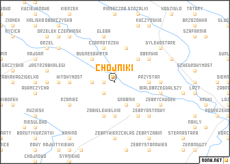
Chojniki (Poland)Chojniki is a town in Poland. An overview map of the region around Chojniki is displayed below.
regional and 3d topo map of Chojniki, Poland ::
Chojniki airports ::
The nearest airport is WAW - Warsaw Okecie, located 111.3 km south of Chojniki.
Other airports nearby include KGD - Kaliningrad Khrabrovo (202.3 km north), Nearby towns ::
Mostówek (1.1km west) //
Wyszel (1.9km north) //
Mostowo (2.2km south west) //
Grabówek (2.2km west) //
Grabnik (3.9km south) //
Nowa Wieś (4.3km south east) //
Budne-Sowięta (4.3km north west) //
Aleksandrowo (4.3km north east) //
Piliki (5.6km south) //
Przystań (3.3km east) //
Zabiele Wielkie (5.7km south) //
Czarnotrzew (5.7km north) //
Chudek (5.7km north) //
Działyń (6.0km south) //
Oberwia (5.0km north east) //
Witowy Most (4.4km west) //
Olszewka (4.4km east) //
Białobrzeg Dalszy (4.8km south east) //
Gleba (7.5km north) //
Żebry Ostrowy (6.5km south east) //
Rżaniec (5.8km south west) //
Żebry Chudek (5.8km south east) //
Dylewo Stare (7.1km north east) //
Dylewo (7.1km north east) //
Czerwińsk (8.6km north west) //
[all distances 'as the bird flies' and approximate]  Places with similar names to Chojniki, Poland ::
Disclaimer :: Information on this page comes without warranty of any kind |
||
|
Where is Chojniki? Elevation and coordinates ::
Latitude (lat): 53°8'0"N Longitude (lon): 21°23'0"E
Elevation (approx.): 100m (map arrows pan, magnifying glasses zoom) |
||
|
Visiting Chojniki? Hotel/Accommodation ::
Book a hotel in Chojniki Travel Guide ::
Buy a travel guide for Poland rental cars ::
car rental offers GPS waypoint ::
download a GPX waypoint (PoI) of Chojniki for your GPS receiver
|
||